You are here: Home > Network List > KN - Kyrgyz Seismic Telemetry Network Stations List
> Station CHM KN.CHM > Earthquake Result Viewer
CHM KN.CHM - Earthquake Result Viewer
| Earthquake location: |
Off East Coast Of Honshu, Japan |
| Earthquake latitude/longitude: |
38.5/143.2 |
| Earthquake time(UTC): |
2005/08/24 (236) 10:14:47 GMT |
| Earthquake Depth: |
10 km |
| Earthquake Magnitude: |
5.7 MB, 5.9 MW, 5.7 MW |
| Earthquake Catalog/Contributor: |
WHDF/NEIC |
|
| Network: |
KN Kyrgyz Seismic Telemetry Network |
| Station: |
CHM KN.CHM |
| Lat/Lon: |
43.00 N/74.75 E |
| Elevation: |
655 m |
|
| Distance: |
50.7 deg |
| Az: |
298.215 deg |
| Baz: |
70.507 deg |
| Ray Param: |
0.06786268 |
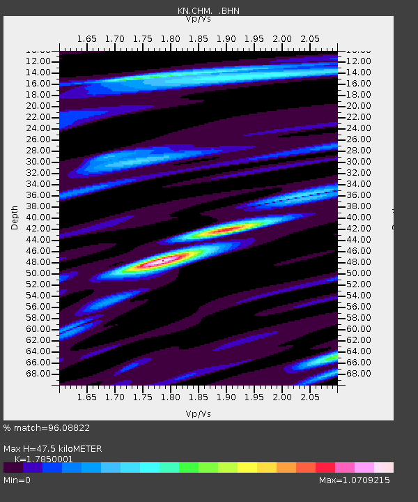
| Estimated Moho Depth: |
47.5 km |
| Estimated Crust Vp/Vs: |
1.79 |
| Assumed Crust Vp: |
6.306 km/s |
| Estimated Crust Vs: |
3.533 km/s |
| Estimated Crust Poisson's Ratio: |
0.27 |
|
| Radial Match: |
96.08822 % |
| Radial Bump: |
337 |
| Transverse Match: |
88.11618 % |
| Transverse Bump: |
400 |
| SOD ConfigId: |
2500 |
| Insert Time: |
2010-03-08 19:30:25.109 +0000 |
| GWidth: |
2.5 |
| Max Bumps: |
400 |
| Tol: |
0.001 |
|
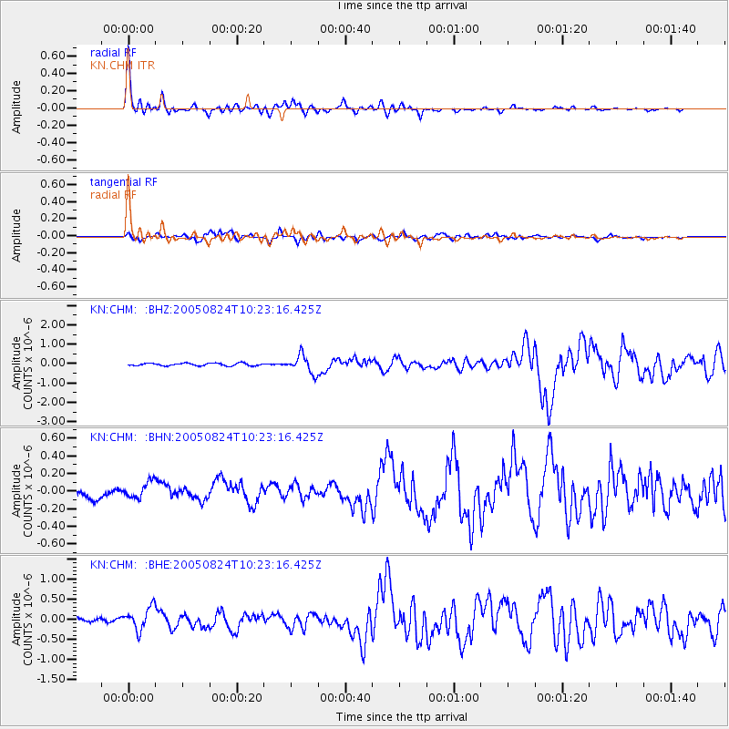
Signal To Noise
| Channel | StoN | STA | LTA |
| KN:CHM: :BHN:20050824T10:23:16.425Z | 2.026648 | 9.659942E-8 | 4.7664628E-8 |
| KN:CHM: :BHE:20050824T10:23:16.425Z | 5.333374 | 2.8121423E-7 | 5.2727266E-8 |
| KN:CHM: :BHZ:20050824T10:23:16.425Z | 7.178115 | 4.7008734E-7 | 6.548897E-8 |
| Arrivals |
| Ps | 6.2 SECOND |
| PpPs | 20 SECOND |
| PsPs/PpSs | 26 SECOND |


