You are here: Home > Network List > US - United States National Seismic Network Stations List
> Station DGMT Dagmar, Montana, USA > Earthquake Result Viewer
DGMT Dagmar, Montana, USA - Earthquake Result Viewer
*The percent match for this event was below the threshold and hence no stack was calculated.
| Earthquake location: |
Kuril Islands |
| Earthquake latitude/longitude: |
43.9/147.7 |
| Earthquake time(UTC): |
2017/05/22 (142) 11:00:57 GMT |
| Earthquake Depth: |
54 km |
| Earthquake Magnitude: |
5.5 Mww |
| Earthquake Catalog/Contributor: |
NEIC PDE/us |
|
| Network: |
US United States National Seismic Network |
| Station: |
DGMT Dagmar, Montana, USA |
| Lat/Lon: |
48.47 N/104.20 W |
| Elevation: |
0.0 m |
|
| Distance: |
68.5 deg |
| Az: |
42.844 deg |
| Baz: |
312.412 deg |
| Ray Param: |
$rayparam |
*The percent match for this event was below the threshold and hence was not used in the summary stack. |
|
| Radial Match: |
52.206844 % |
| Radial Bump: |
400 |
| Transverse Match: |
43.113895 % |
| Transverse Bump: |
400 |
| SOD ConfigId: |
2028011 |
| Insert Time: |
2017-06-05 11:08:47.083 +0000 |
| GWidth: |
2.5 |
| Max Bumps: |
400 |
| Tol: |
0.001 |
|
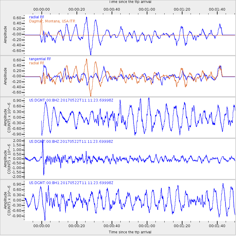
Signal To Noise
| Channel | StoN | STA | LTA |
| US:DGMT:00:BHZ:20170522T11:11:23.69998Z | 7.7686267 | 7.16687E-7 | 9.225402E-8 |
| US:DGMT:00:BH1:20170522T11:11:23.69998Z | 1.6392435 | 5.524803E-7 | 3.370337E-7 |
| US:DGMT:00:BH2:20170522T11:11:23.69998Z | 0.59635377 | 2.1773745E-7 | 3.6511457E-7 |
| Arrivals |
| Ps | |
| PpPs | |
| PsPs/PpSs | |


