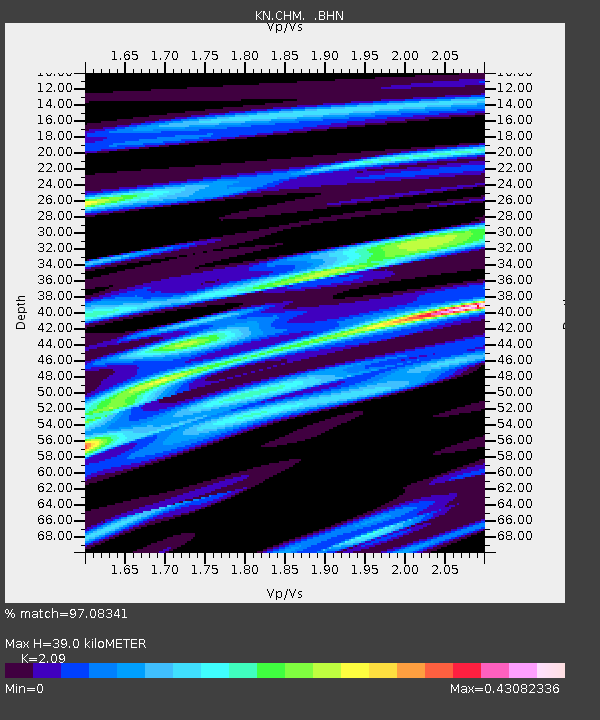
CHM KN.CHM - Earthquake Result Viewer
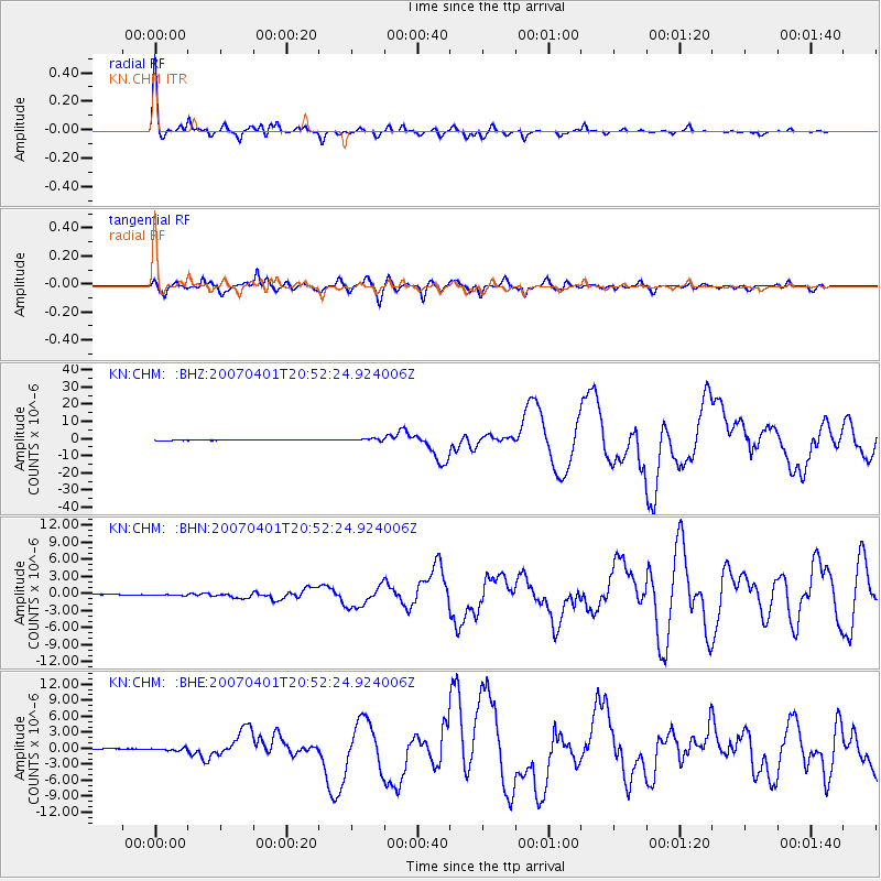
Earthquake location: Solomon Islands
Earthquake latitude/longitude: -8.5/157.0
Earthquake time(UTC): 2007/04/01 (091) 20:39:56 GMT
Earthquake Depth: 10 km
Earthquake Magnitude: 6.8 MB, 7.9 MS, 8.1 MW, 7.7 ME
Earthquake Catalog/Contributor: WHDF/NEIC
Network: KN Kyrgyz Seismic Telemetry Network
Station: CHM KN.CHM
Lat/Lon: 43.00 N/74.75 E
Elevation: 655 m
Distance: 90.1 deg
Az: 313.362 deg
Baz: 101.384 deg
Ray Param: 0.041696515
Estimated Moho Depth: 39.0 km
Estimated Crust Vp/Vs: 2.09
Assumed Crust Vp: 6.306 km/s
Estimated Crust Vs: 3.017 km/s
Estimated Crust Poisson's Ratio: 0.35
Radial Match: 97.08341 %
Radial Bump: 272
Transverse Match: 89.67166 %
Transverse Bump: 400
SOD ConfigId: 2564
Insert Time: 2010-03-08 19:30:31.209 +0000
GWidth: 2.5
Max Bumps: 400
Tol: 0.001

Signal To Noise

ChannelStoNSTALTA
KN:CHM: :BHN:20070401T20:52:24.924006Z1.77550641.3503771E-77.605588E-8
KN:CHM: :BHE:20070401T20:52:24.924006Z0.990846343.0957608E-73.1243601E-7
KN:CHM: :BHZ:20070401T20:52:24.924006Z7.7285476.5060044E-78.4181465E-8
Arrivals
Ps6.9 SECOND
PpPs19 SECOND
PsPs/PpSs26 SECOND