You are here: Home > Network List > TA - USArray Transportable Network (new EarthScope stations) Stations List
> Station M24K Tolsona, Glennallen, AK, USA > Earthquake Result Viewer
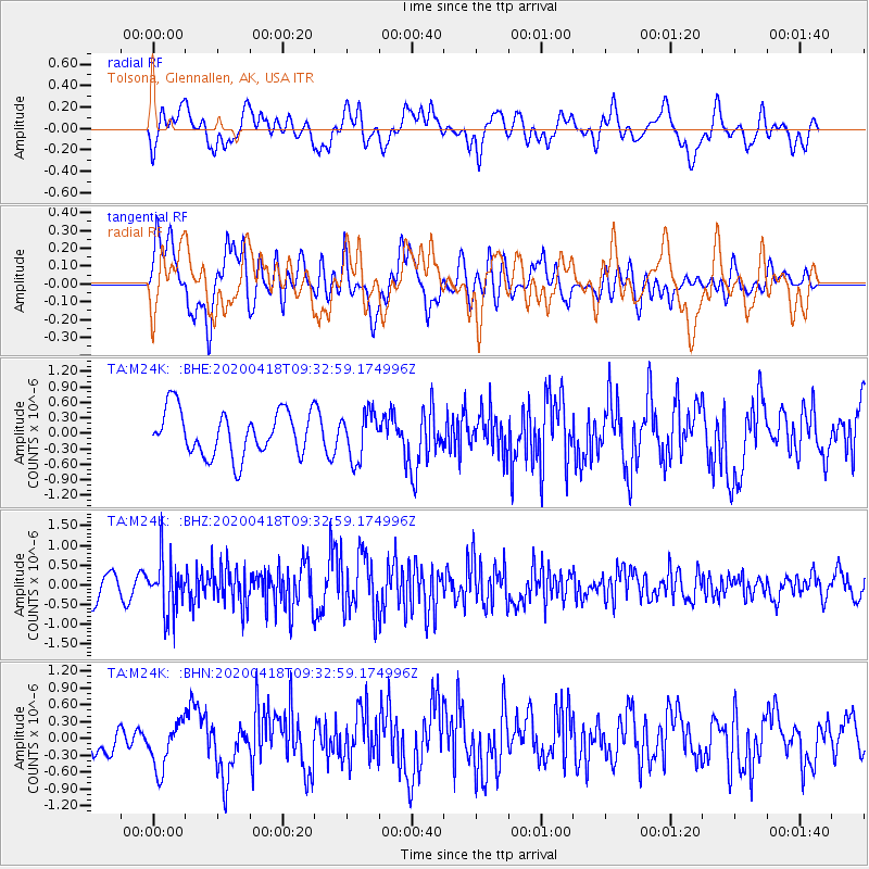
M24K Tolsona, Glennallen, AK, USA - Earthquake Result Viewer
*The percent match for this event was below the threshold and hence no stack was calculated.
| Earthquake location: |
Bonin Islands, Japan Region |
| Earthquake latitude/longitude: |
27.2/140.1 |
| Earthquake time(UTC): |
2020/04/18 (109) 09:24:17 GMT |
| Earthquake Depth: |
468 km |
| Earthquake Magnitude: |
5.7 Mww |
| Earthquake Catalog/Contributor: |
NEIC PDE/us |
|
| Network: |
TA USArray Transportable Network (new EarthScope stations) |
| Station: |
M24K Tolsona, Glennallen, AK, USA |
| Lat/Lon: |
62.11 N/146.18 W |
| Elevation: |
908 m |
|
| Distance: |
58.8 deg |
| Az: |
31.867 deg |
| Baz: |
269.589 deg |
| Ray Param: |
$rayparam |
*The percent match for this event was below the threshold and hence was not used in the summary stack. |
|
| Radial Match: |
54.058784 % |
| Radial Bump: |
400 |
| Transverse Match: |
53.72886 % |
| Transverse Bump: |
400 |
| SOD ConfigId: |
21166931 |
| Insert Time: |
2020-05-02 09:42:23.679 +0000 |
| GWidth: |
2.5 |
| Max Bumps: |
400 |
| Tol: |
0.001 |
|
Signal To Noise
| Channel | StoN | STA | LTA |
| TA:M24K: :BHZ:20200418T09:32:59.174996Z | 1.5226357 | 6.599217E-7 | 4.3340748E-7 |
| TA:M24K: :BHN:20200418T09:32:59.174996Z | 1.4153 | 4.1810247E-7 | 2.9541613E-7 |
| TA:M24K: :BHE:20200418T09:32:59.174996Z | 1.0391648 | 4.5249186E-7 | 4.35438E-7 |
| Arrivals |
| Ps | |
| PpPs | |
| PsPs/PpSs | |


