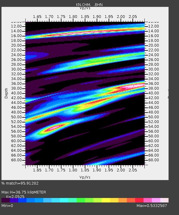
CHM KN.CHM - Earthquake Result Viewer

Earthquake location: Mariana Islands
Earthquake latitude/longitude: 21.0/144.7
Earthquake time(UTC): 2007/01/30 (030) 21:37:45 GMT
Earthquake Depth: 30 km
Earthquake Magnitude: 6.3 MB, 6.5 MS, 6.6 MW, 6.5 MW
Earthquake Catalog/Contributor: WHDF/NEIC
Network: KN Kyrgyz Seismic Telemetry Network
Station: CHM KN.CHM
Lat/Lon: 43.00 N/74.75 E
Elevation: 655 m
Distance: 61.5 deg
Az: 308.359 deg
Baz: 87.167 deg
Ray Param: 0.060782436
Estimated Moho Depth: 36.75 km
Estimated Crust Vp/Vs: 2.05
Assumed Crust Vp: 6.306 km/s
Estimated Crust Vs: 3.072 km/s
Estimated Crust Poisson's Ratio: 0.34
Radial Match: 95.91282 %
Radial Bump: 289
Transverse Match: 87.40621 %
Transverse Bump: 400
SOD ConfigId: 2564
Insert Time: 2010-03-08 19:30:37.570 +0000
GWidth: 2.5
Max Bumps: 400
Tol: 0.001

Signal To Noise

ChannelStoNSTALTA
KN:CHM: :BHN:20070130T21:47:28.97502Z2.51909422.8580567E-71.1345573E-7
KN:CHM: :BHE:20070130T21:47:28.97502Z12.806161.3051725E-61.0191756E-7
KN:CHM: :BHZ:20070130T21:47:28.97502Z43.6524622.689621E-66.1614415E-8
Arrivals
Ps6.4 SECOND
PpPs17 SECOND
PsPs/PpSs24 SECOND