You are here: Home > Network List > TJ - Tajikistan National Seismic Network Stations List
> Station GARM Garm, Tajikistan > Earthquake Result Viewer
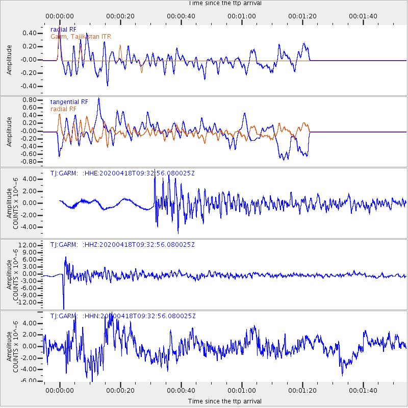
GARM Garm, Tajikistan - Earthquake Result Viewer
*The percent match for this event was below the threshold and hence no stack was calculated.
| Earthquake location: |
Bonin Islands, Japan Region |
| Earthquake latitude/longitude: |
27.2/140.1 |
| Earthquake time(UTC): |
2020/04/18 (109) 09:24:17 GMT |
| Earthquake Depth: |
468 km |
| Earthquake Magnitude: |
5.7 Mww |
| Earthquake Catalog/Contributor: |
NEIC PDE/us |
|
| Network: |
TJ Tajikistan National Seismic Network |
| Station: |
GARM Garm, Tajikistan |
| Lat/Lon: |
39.00 N/70.32 E |
| Elevation: |
1305 m |
|
| Distance: |
58.3 deg |
| Az: |
300.797 deg |
| Baz: |
79.102 deg |
| Ray Param: |
$rayparam |
*The percent match for this event was below the threshold and hence was not used in the summary stack. |
|
| Radial Match: |
69.46902 % |
| Radial Bump: |
400 |
| Transverse Match: |
53.099552 % |
| Transverse Bump: |
400 |
| SOD ConfigId: |
21166931 |
| Insert Time: |
2020-05-02 09:43:09.552 +0000 |
| GWidth: |
2.5 |
| Max Bumps: |
400 |
| Tol: |
0.001 |
|
Signal To Noise
| Channel | StoN | STA | LTA |
| TJ:GARM: :HHZ:20200418T09:32:56.080025Z | 7.741954 | 3.76678E-6 | 4.865413E-7 |
| TJ:GARM: :HHN:20200418T09:32:56.080025Z | 1.1205091 | 1.6373453E-6 | 1.4612513E-6 |
| TJ:GARM: :HHE:20200418T09:32:56.080025Z | 3.4415958 | 1.743426E-6 | 5.065749E-7 |
| Arrivals |
| Ps | |
| PpPs | |
| PsPs/PpSs | |


