You are here: Home > Network List > US - United States National Seismic Network Stations List
> Station EGMT Eagleton, Montana, USA > Earthquake Result Viewer
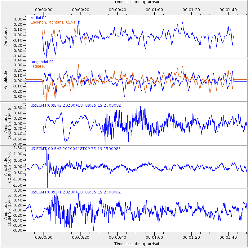
EGMT Eagleton, Montana, USA - Earthquake Result Viewer
*The percent match for this event was below the threshold and hence no stack was calculated.
| Earthquake location: |
Bonin Islands, Japan Region |
| Earthquake latitude/longitude: |
27.2/140.1 |
| Earthquake time(UTC): |
2020/04/18 (109) 09:24:17 GMT |
| Earthquake Depth: |
468 km |
| Earthquake Magnitude: |
5.7 Mww |
| Earthquake Catalog/Contributor: |
NEIC PDE/us |
|
| Network: |
US United States National Seismic Network |
| Station: |
EGMT Eagleton, Montana, USA |
| Lat/Lon: |
48.02 N/109.75 W |
| Elevation: |
1055 m |
|
| Distance: |
82.5 deg |
| Az: |
39.46 deg |
| Baz: |
302.509 deg |
| Ray Param: |
$rayparam |
*The percent match for this event was below the threshold and hence was not used in the summary stack. |
|
| Radial Match: |
57.214863 % |
| Radial Bump: |
400 |
| Transverse Match: |
50.336403 % |
| Transverse Bump: |
400 |
| SOD ConfigId: |
21166931 |
| Insert Time: |
2020-05-02 09:44:21.936 +0000 |
| GWidth: |
2.5 |
| Max Bumps: |
400 |
| Tol: |
0.001 |
|
Signal To Noise
| Channel | StoN | STA | LTA |
| US:EGMT:00:BHZ:20200418T09:35:19.250008Z | 3.0897386 | 5.671437E-7 | 1.8355716E-7 |
| US:EGMT:00:BH1:20200418T09:35:19.250008Z | 1.4144986 | 1.9421928E-7 | 1.373061E-7 |
| US:EGMT:00:BH2:20200418T09:35:19.250008Z | 0.9623099 | 2.7161576E-7 | 2.8225395E-7 |
| Arrivals |
| Ps | |
| PpPs | |
| PsPs/PpSs | |


