You are here: Home > Network List > US - United States National Seismic Network Stations List
> Station LAO LASA Array, Montana, USA > Earthquake Result Viewer
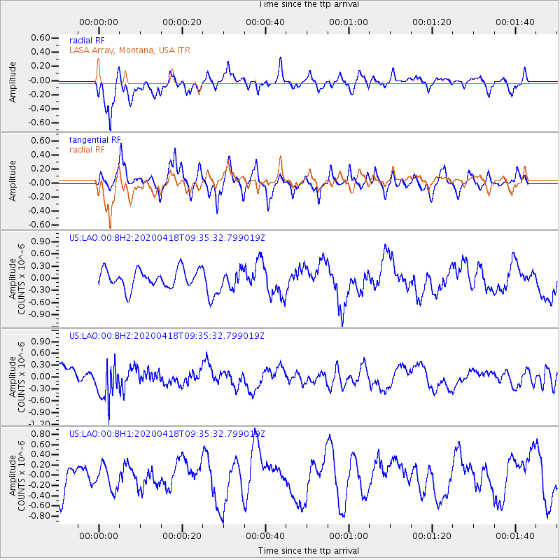
LAO LASA Array, Montana, USA - Earthquake Result Viewer
*The percent match for this event was below the threshold and hence no stack was calculated.
| Earthquake location: |
Bonin Islands, Japan Region |
| Earthquake latitude/longitude: |
27.2/140.1 |
| Earthquake time(UTC): |
2020/04/18 (109) 09:24:17 GMT |
| Earthquake Depth: |
468 km |
| Earthquake Magnitude: |
5.7 Mww |
| Earthquake Catalog/Contributor: |
NEIC PDE/us |
|
| Network: |
US United States National Seismic Network |
| Station: |
LAO LASA Array, Montana, USA |
| Lat/Lon: |
46.69 N/106.22 W |
| Elevation: |
902 m |
|
| Distance: |
85.2 deg |
| Az: |
39.233 deg |
| Baz: |
305.075 deg |
| Ray Param: |
$rayparam |
*The percent match for this event was below the threshold and hence was not used in the summary stack. |
|
| Radial Match: |
59.245903 % |
| Radial Bump: |
400 |
| Transverse Match: |
69.67459 % |
| Transverse Bump: |
356 |
| SOD ConfigId: |
21166931 |
| Insert Time: |
2020-05-02 09:44:27.366 +0000 |
| GWidth: |
2.5 |
| Max Bumps: |
400 |
| Tol: |
0.001 |
|
Signal To Noise
| Channel | StoN | STA | LTA |
| US:LAO:00:BHZ:20200418T09:35:32.799019Z | 2.2741997 | 4.6083954E-7 | 2.0263812E-7 |
| US:LAO:00:BH1:20200418T09:35:32.799019Z | 0.82756823 | 2.3423343E-7 | 2.8303822E-7 |
| US:LAO:00:BH2:20200418T09:35:32.799019Z | 0.9692919 | 2.1743904E-7 | 2.243277E-7 |
| Arrivals |
| Ps | |
| PpPs | |
| PsPs/PpSs | |


