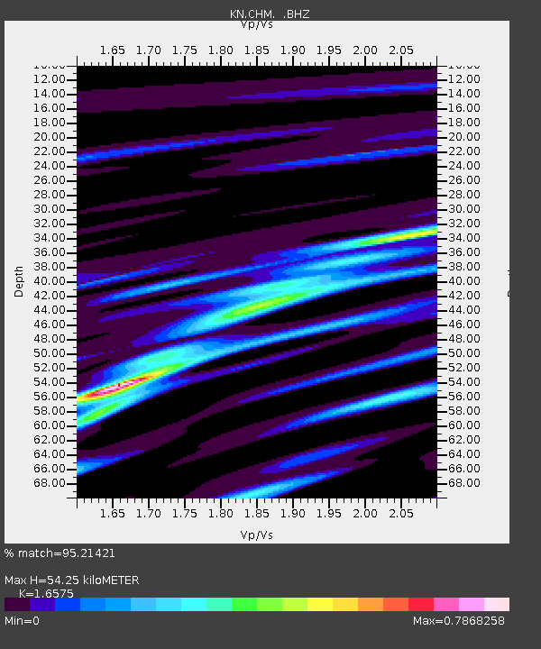
CHM KN.CHM - Earthquake Result Viewer
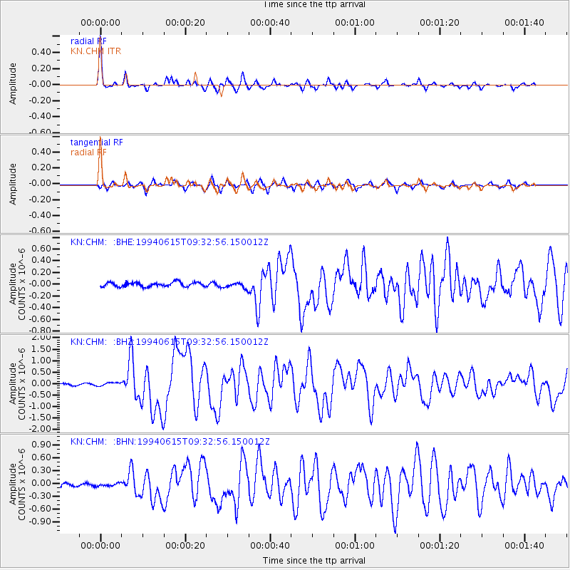
Earthquake location: South Of Java, Indonesia
Earthquake latitude/longitude: -10.4/113.5
Earthquake time(UTC): 1994/06/15 (166) 09:22:57 GMT
Earthquake Depth: 33 km
Earthquake Magnitude: 5.8 MB, 6.1 MS, 5.9 UNKNOWN, 6.0 MW
Earthquake Catalog/Contributor: WHDF/NEIC
Network: KN Kyrgyz Seismic Telemetry Network
Station: CHM KN.CHM
Lat/Lon: 43.00 N/74.75 E
Elevation: 655 m
Distance: 63.9 deg
Az: 329.208 deg
Baz: 136.65 deg
Ray Param: 0.059248794
Estimated Moho Depth: 54.25 km
Estimated Crust Vp/Vs: 1.66
Assumed Crust Vp: 6.306 km/s
Estimated Crust Vs: 3.805 km/s
Estimated Crust Poisson's Ratio: 0.21
Radial Match: 95.21421 %
Radial Bump: 276
Transverse Match: 90.87806 %
Transverse Bump: 382
SOD ConfigId: 4480
Insert Time: 2010-03-08 19:31:42.985 +0000
GWidth: 2.5
Max Bumps: 400
Tol: 0.001

Signal To Noise

ChannelStoNSTALTA
KN:CHM: :BHZ:19940615T09:32:56.150012Z1.57842677.426081E-84.7047358E-8
KN:CHM: :BHN:19940615T09:32:56.150012Z0.82732273.2703433E-83.952923E-8
KN:CHM: :BHE:19940615T09:32:56.150012Z1.35720125.0315915E-83.7073292E-8
Arrivals
Ps5.9 SECOND
PpPs22 SECOND
PsPs/PpSs28 SECOND