You are here: Home > Network List > AV - Alaska Volcano Observatory Stations List
> Station PLBL Mt. Peulik Volcano, Alaska > Earthquake Result Viewer
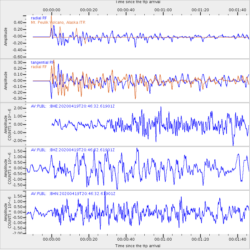
PLBL Mt. Peulik Volcano, Alaska - Earthquake Result Viewer
*The percent match for this event was below the threshold and hence no stack was calculated.
| Earthquake location: |
Near East Coast Of Honshu, Japan |
| Earthquake latitude/longitude: |
38.9/141.9 |
| Earthquake time(UTC): |
2020/04/19 (110) 20:39:05 GMT |
| Earthquake Depth: |
38 km |
| Earthquake Magnitude: |
6.3 mww |
| Earthquake Catalog/Contributor: |
NEIC PDE/us |
|
| Network: |
AV Alaska Volcano Observatory |
| Station: |
PLBL Mt. Peulik Volcano, Alaska |
| Lat/Lon: |
57.70 N/156.82 W |
| Elevation: |
461 m |
|
| Distance: |
43.2 deg |
| Az: |
43.468 deg |
| Baz: |
271.615 deg |
| Ray Param: |
$rayparam |
*The percent match for this event was below the threshold and hence was not used in the summary stack. |
|
| Radial Match: |
63.173267 % |
| Radial Bump: |
400 |
| Transverse Match: |
56.03129 % |
| Transverse Bump: |
400 |
| SOD ConfigId: |
21166931 |
| Insert Time: |
2020-05-03 20:44:10.769 +0000 |
| GWidth: |
2.5 |
| Max Bumps: |
400 |
| Tol: |
0.001 |
|
Signal To Noise
| Channel | StoN | STA | LTA |
| AV:PLBL: :BHZ:20200419T20:46:32.61901Z | 3.6451614 | 5.449072E-7 | 1.4948782E-7 |
| AV:PLBL: :BHN:20200419T20:46:32.61901Z | 1.0469537 | 3.8917085E-7 | 3.717174E-7 |
| AV:PLBL: :BHE:20200419T20:46:32.61901Z | 1.6451553 | 4.7615305E-7 | 2.8942742E-7 |
| Arrivals |
| Ps | |
| PpPs | |
| PsPs/PpSs | |


