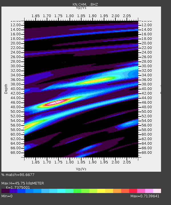
CHM KN.CHM - Earthquake Result Viewer

Earthquake location: South Of Java, Indonesia
Earthquake latitude/longitude: -10.5/113.0
Earthquake time(UTC): 1994/06/02 (153) 18:17:36 GMT
Earthquake Depth: 39 km
Earthquake Magnitude: 5.5 MB, 7.2 MS, 6.8 UNKNOWN, 7.7 MW
Earthquake Catalog/Contributor: WHDF/NEIC
Network: KN Kyrgyz Seismic Telemetry Network
Station: CHM KN.CHM
Lat/Lon: 43.00 N/74.75 E
Elevation: 655 m
Distance: 63.6 deg
Az: 329.558 deg
Baz: 137.215 deg
Ray Param: 0.059380267
Estimated Moho Depth: 45.75 km
Estimated Crust Vp/Vs: 1.74
Assumed Crust Vp: 6.306 km/s
Estimated Crust Vs: 3.629 km/s
Estimated Crust Poisson's Ratio: 0.25
Radial Match: 98.6677 %
Radial Bump: 285
Transverse Match: 90.722145 %
Transverse Bump: 400
SOD ConfigId: 4480
Insert Time: 2010-03-08 19:32:01.175 +0000
GWidth: 2.5
Max Bumps: 400
Tol: 0.001

Signal To Noise

ChannelStoNSTALTA
KN:CHM: :BHZ:19940602T18:27:33.099011Z3.67062263.011907E-78.205439E-8
KN:CHM: :BHN:19940602T18:27:33.099011Z1.81600139.0688644E-84.993864E-8
KN:CHM: :BHE:19940602T18:27:33.099011Z2.40517471.1064914E-74.6004615E-8
Arrivals
Ps5.6 SECOND
PpPs19 SECOND
PsPs/PpSs25 SECOND