You are here: Home > Network List > CI - Caltech Regional Seismic Network Stations List
> Station MPP McPhearson Peak > Earthquake Result Viewer
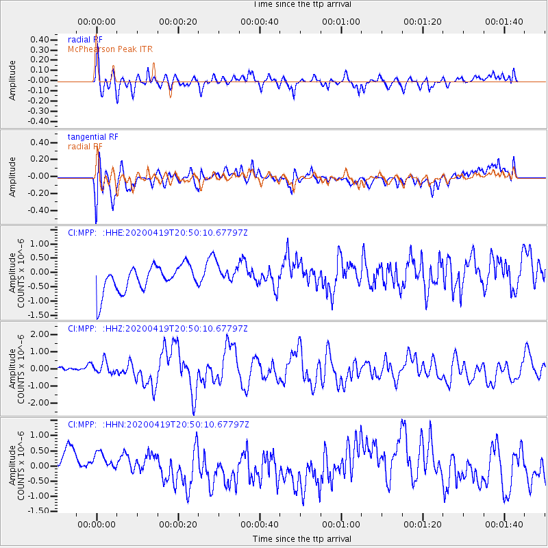
MPP McPhearson Peak - Earthquake Result Viewer
*The percent match for this event was below the threshold and hence no stack was calculated.
| Earthquake location: |
Near East Coast Of Honshu, Japan |
| Earthquake latitude/longitude: |
38.9/141.9 |
| Earthquake time(UTC): |
2020/04/19 (110) 20:39:05 GMT |
| Earthquake Depth: |
38 km |
| Earthquake Magnitude: |
6.3 mww |
| Earthquake Catalog/Contributor: |
NEIC PDE/us |
|
| Network: |
CI Caltech Regional Seismic Network |
| Station: |
MPP McPhearson Peak |
| Lat/Lon: |
34.89 N/119.81 W |
| Elevation: |
1739 m |
|
| Distance: |
74.7 deg |
| Az: |
57.511 deg |
| Baz: |
306.821 deg |
| Ray Param: |
$rayparam |
*The percent match for this event was below the threshold and hence was not used in the summary stack. |
|
| Radial Match: |
65.43975 % |
| Radial Bump: |
400 |
| Transverse Match: |
49.926334 % |
| Transverse Bump: |
390 |
| SOD ConfigId: |
21166931 |
| Insert Time: |
2020-05-03 20:47:28.462 +0000 |
| GWidth: |
2.5 |
| Max Bumps: |
400 |
| Tol: |
0.001 |
|
Signal To Noise
| Channel | StoN | STA | LTA |
| CI:MPP: :HHZ:20200419T20:50:10.67797Z | 1.3749025 | 4.8502307E-7 | 3.5276906E-7 |
| CI:MPP: :HHN:20200419T20:50:10.67797Z | 0.72331566 | 6.002333E-7 | 8.2983587E-7 |
| CI:MPP: :HHE:20200419T20:50:10.67797Z | 0.74566096 | 3.3956474E-7 | 4.553876E-7 |
| Arrivals |
| Ps | |
| PpPs | |
| PsPs/PpSs | |


