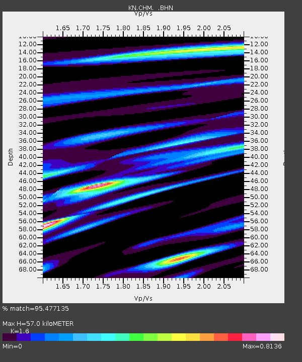
CHM KN.CHM - Earthquake Result Viewer
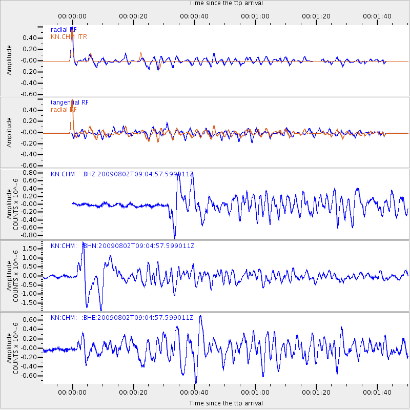
Earthquake location: Irian Jaya Region, Indonesia
Earthquake latitude/longitude: -0.5/132.9
Earthquake time(UTC): 2009/08/02 (214) 08:54:35 GMT
Earthquake Depth: 35 km
Earthquake Magnitude: 5.8 MB, 5.8 MS, 6.1 MW, 6.0 MW
Earthquake Catalog/Contributor: WHDF/NEIC
Network: KN Kyrgyz Seismic Telemetry Network
Station: CHM KN.CHM
Lat/Lon: 43.00 N/74.75 E
Elevation: 655 m
Distance: 67.6 deg
Az: 317.608 deg
Baz: 113.229 deg
Ray Param: 0.05681954
Estimated Moho Depth: 57.0 km
Estimated Crust Vp/Vs: 1.60
Assumed Crust Vp: 6.306 km/s
Estimated Crust Vs: 3.941 km/s
Estimated Crust Poisson's Ratio: 0.18
Radial Match: 95.477135 %
Radial Bump: 400
Transverse Match: 90.84529 %
Transverse Bump: 400
SOD ConfigId: 2622
Insert Time: 2010-03-08 19:32:11.157 +0000
GWidth: 2.5
Max Bumps: 400
Tol: 0.001

Signal To Noise

ChannelStoNSTALTA
KN:CHM: :BHN:20090802T09:04:57.599011Z23.1399638.6347086E-73.7315136E-8
KN:CHM: :BHE:20090802T09:04:57.599011Z5.0467381.6691766E-73.3074365E-8
KN:CHM: :BHZ:20090802T09:04:57.599011Z12.3039753.8805044E-73.1538622E-8
Arrivals
Ps5.7 SECOND
PpPs23 SECOND
PsPs/PpSs28 SECOND