You are here: Home > Network List > GB - Great Britain Seismograph Network Stations List
> Station FOEL TREGEIROG, WALES > Earthquake Result Viewer
FOEL TREGEIROG, WALES - Earthquake Result Viewer
| Earthquake location: |
Near East Coast Of Honshu, Japan |
| Earthquake latitude/longitude: |
38.9/141.9 |
| Earthquake time(UTC): |
2020/04/19 (110) 20:39:05 GMT |
| Earthquake Depth: |
38 km |
| Earthquake Magnitude: |
6.3 mww |
| Earthquake Catalog/Contributor: |
NEIC PDE/us |
|
| Network: |
GB Great Britain Seismograph Network |
| Station: |
FOEL TREGEIROG, WALES |
| Lat/Lon: |
52.89 N/3.20 W |
| Elevation: |
449 m |
|
| Distance: |
83.7 deg |
| Az: |
339.604 deg |
| Baz: |
26.661 deg |
| Ray Param: |
0.045949437 |
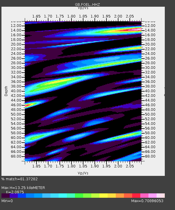
| Estimated Moho Depth: |
13.25 km |
| Estimated Crust Vp/Vs: |
2.10 |
| Assumed Crust Vp: |
6.276 km/s |
| Estimated Crust Vs: |
2.992 km/s |
| Estimated Crust Poisson's Ratio: |
0.35 |
|
| Radial Match: |
81.37282 % |
| Radial Bump: |
400 |
| Transverse Match: |
71.23734 % |
| Transverse Bump: |
400 |
| SOD ConfigId: |
21166931 |
| Insert Time: |
2020-05-03 20:50:55.281 +0000 |
| GWidth: |
2.5 |
| Max Bumps: |
400 |
| Tol: |
0.001 |
|

Signal To Noise
| Channel | StoN | STA | LTA |
| GB:FOEL: :HHZ:20200419T20:50:59.700003Z | 12.478191 | 9.943103E-7 | 7.968385E-8 |
| GB:FOEL: :HHN:20200419T20:50:59.700003Z | 5.4554935 | 4.082692E-7 | 7.483634E-8 |
| GB:FOEL: :HHE:20200419T20:50:59.700003Z | 2.704115 | 1.7137629E-7 | 6.3376106E-8 |
| Arrivals |
| Ps | 2.4 SECOND |
| PpPs | 6.4 SECOND |
| PsPs/PpSs | 8.8 SECOND |


