You are here: Home > Network List > GS - US Geological Survey Networks Stations List
> Station ASA5 ASA5 > Earthquake Result Viewer
ASA5 ASA5 - Earthquake Result Viewer
| Earthquake location: |
Near East Coast Of Honshu, Japan |
| Earthquake latitude/longitude: |
38.9/141.9 |
| Earthquake time(UTC): |
2020/04/19 (110) 20:39:05 GMT |
| Earthquake Depth: |
38 km |
| Earthquake Magnitude: |
6.3 mww |
| Earthquake Catalog/Contributor: |
NEIC PDE/us |
|
| Network: |
GS US Geological Survey Networks |
| Station: |
ASA5 ASA5 |
| Lat/Lon: |
34.94 N/106.46 W |
| Elevation: |
1835 m |
|
| Distance: |
83.1 deg |
| Az: |
50.301 deg |
| Baz: |
313.057 deg |
| Ray Param: |
0.046394438 |
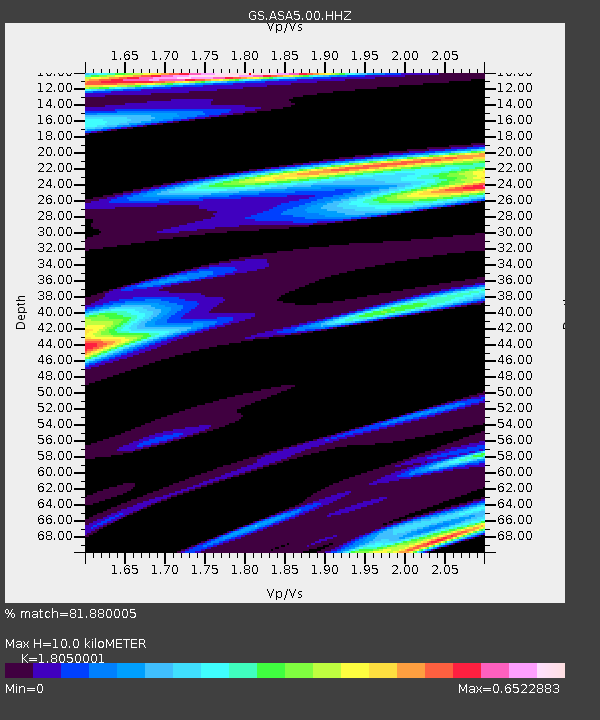
| Estimated Moho Depth: |
10.0 km |
| Estimated Crust Vp/Vs: |
1.81 |
| Assumed Crust Vp: |
6.502 km/s |
| Estimated Crust Vs: |
3.602 km/s |
| Estimated Crust Poisson's Ratio: |
0.28 |
|
| Radial Match: |
81.880005 % |
| Radial Bump: |
331 |
| Transverse Match: |
49.84116 % |
| Transverse Bump: |
370 |
| SOD ConfigId: |
21166931 |
| Insert Time: |
2020-05-03 20:51:52.117 +0000 |
| GWidth: |
2.5 |
| Max Bumps: |
400 |
| Tol: |
0.001 |
|

Signal To Noise
| Channel | StoN | STA | LTA |
| GS:ASA5:00:HHZ:20200419T20:50:56.479972Z | 1.9928174 | 5.2829273E-7 | 2.650984E-7 |
| GS:ASA5:00:HH1:20200419T20:50:56.479972Z | 0.71352273 | 2.513667E-7 | 3.522897E-7 |
| GS:ASA5:00:HH2:20200419T20:50:56.479972Z | 1.9648969 | 3.2852674E-7 | 1.6719795E-7 |
| Arrivals |
| Ps | 1.3 SECOND |
| PpPs | 4.2 SECOND |
| PsPs/PpSs | 5.5 SECOND |


