You are here: Home > Network List > GS - US Geological Survey Networks Stations List
> Station ASA6 ASA6 > Earthquake Result Viewer
ASA6 ASA6 - Earthquake Result Viewer
| Earthquake location: |
Near East Coast Of Honshu, Japan |
| Earthquake latitude/longitude: |
38.9/141.9 |
| Earthquake time(UTC): |
2020/04/19 (110) 20:39:05 GMT |
| Earthquake Depth: |
38 km |
| Earthquake Magnitude: |
6.3 mww |
| Earthquake Catalog/Contributor: |
NEIC PDE/us |
|
| Network: |
GS US Geological Survey Networks |
| Station: |
ASA6 ASA6 |
| Lat/Lon: |
34.94 N/106.46 W |
| Elevation: |
1840 m |
|
| Distance: |
83.1 deg |
| Az: |
50.299 deg |
| Baz: |
313.058 deg |
| Ray Param: |
0.046393313 |
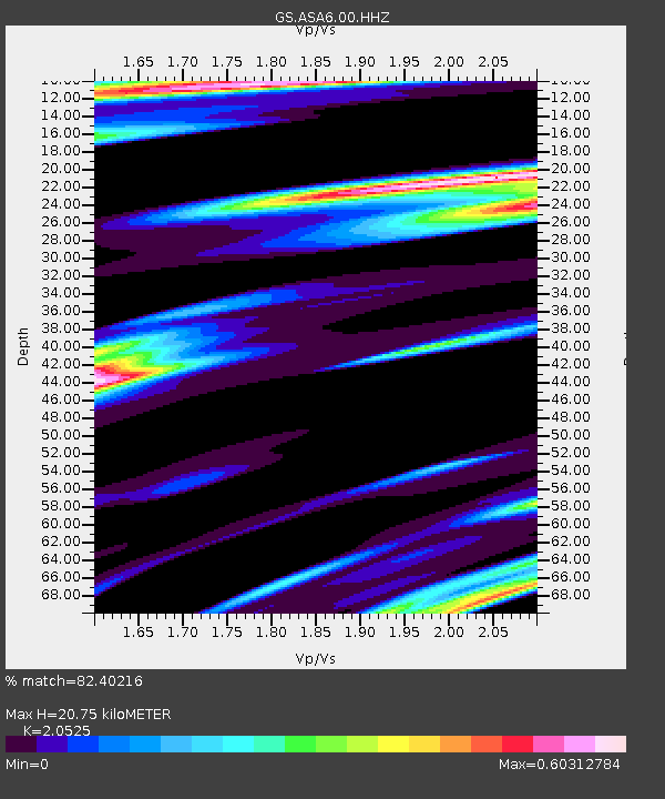
| Estimated Moho Depth: |
20.75 km |
| Estimated Crust Vp/Vs: |
2.05 |
| Assumed Crust Vp: |
6.502 km/s |
| Estimated Crust Vs: |
3.168 km/s |
| Estimated Crust Poisson's Ratio: |
0.34 |
|
| Radial Match: |
82.40216 % |
| Radial Bump: |
300 |
| Transverse Match: |
51.575317 % |
| Transverse Bump: |
351 |
| SOD ConfigId: |
21166931 |
| Insert Time: |
2020-05-03 20:51:54.393 +0000 |
| GWidth: |
2.5 |
| Max Bumps: |
400 |
| Tol: |
0.001 |
|

Signal To Noise
| Channel | StoN | STA | LTA |
| GS:ASA6:00:HHZ:20200419T20:50:56.489981Z | 1.9638487 | 5.2488446E-7 | 2.6727335E-7 |
| GS:ASA6:00:HH1:20200419T20:50:56.489981Z | 0.73066133 | 2.61273E-7 | 3.5758427E-7 |
| GS:ASA6:00:HH2:20200419T20:50:56.489981Z | 1.9856509 | 3.3104018E-7 | 1.667162E-7 |
| Arrivals |
| Ps | 3.4 SECOND |
| PpPs | 9.5 SECOND |
| PsPs/PpSs | 13 SECOND |


