You are here: Home > Network List > MM - Myanmar National Seismic Network Stations List
> Station NGU Ngaung U, Myanmar > Earthquake Result Viewer
NGU Ngaung U, Myanmar - Earthquake Result Viewer
| Earthquake location: |
Near East Coast Of Honshu, Japan |
| Earthquake latitude/longitude: |
38.9/141.9 |
| Earthquake time(UTC): |
2020/04/19 (110) 20:39:05 GMT |
| Earthquake Depth: |
38 km |
| Earthquake Magnitude: |
6.3 mww |
| Earthquake Catalog/Contributor: |
NEIC PDE/us |
|
| Network: |
MM Myanmar National Seismic Network |
| Station: |
NGU Ngaung U, Myanmar |
| Lat/Lon: |
21.21 N/94.92 E |
| Elevation: |
70 m |
|
| Distance: |
43.8 deg |
| Az: |
260.239 deg |
| Baz: |
55.487 deg |
| Ray Param: |
0.072204836 |
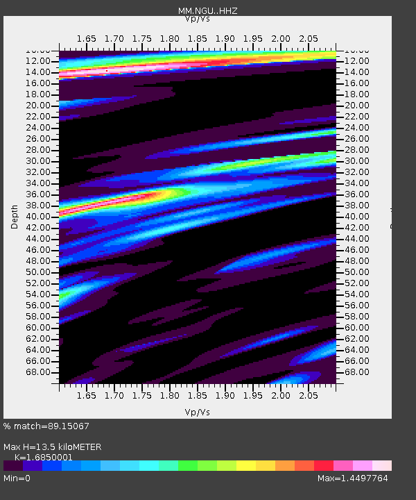
| Estimated Moho Depth: |
13.5 km |
| Estimated Crust Vp/Vs: |
1.69 |
| Assumed Crust Vp: |
6.036 km/s |
| Estimated Crust Vs: |
3.582 km/s |
| Estimated Crust Poisson's Ratio: |
0.23 |
|
| Radial Match: |
89.15067 % |
| Radial Bump: |
400 |
| Transverse Match: |
77.067276 % |
| Transverse Bump: |
400 |
| SOD ConfigId: |
21166931 |
| Insert Time: |
2020-05-03 20:55:19.158 +0000 |
| GWidth: |
2.5 |
| Max Bumps: |
400 |
| Tol: |
0.001 |
|

Signal To Noise
| Channel | StoN | STA | LTA |
| MM:NGU: :HHZ:20200419T20:46:37.920005Z | 39.241886 | 4.7907415E-6 | 1.2208234E-7 |
| MM:NGU: :HHN:20200419T20:46:37.920005Z | 8.60234 | 9.796115E-7 | 1.13877334E-7 |
| MM:NGU: :HHE:20200419T20:46:37.920005Z | 7.998817 | 1.3886237E-6 | 1.7360364E-7 |
| Arrivals |
| Ps | 1.6 SECOND |
| PpPs | 5.7 SECOND |
| PsPs/PpSs | 7.3 SECOND |


