You are here: Home > Network List > MM - Myanmar National Seismic Network Stations List
> Station YGN Yangon, Yangon, Myanmar > Earthquake Result Viewer
YGN Yangon, Yangon, Myanmar - Earthquake Result Viewer
| Earthquake location: |
Near East Coast Of Honshu, Japan |
| Earthquake latitude/longitude: |
38.9/141.9 |
| Earthquake time(UTC): |
2020/04/19 (110) 20:39:05 GMT |
| Earthquake Depth: |
38 km |
| Earthquake Magnitude: |
6.3 mww |
| Earthquake Catalog/Contributor: |
NEIC PDE/us |
|
| Network: |
MM Myanmar National Seismic Network |
| Station: |
YGN Yangon, Yangon, Myanmar |
| Lat/Lon: |
16.86 N/96.15 E |
| Elevation: |
20 m |
|
| Distance: |
45.5 deg |
| Az: |
254.305 deg |
| Baz: |
51.665 deg |
| Ray Param: |
0.07118012 |
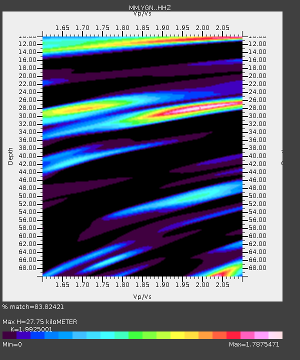
| Estimated Moho Depth: |
27.75 km |
| Estimated Crust Vp/Vs: |
1.99 |
| Assumed Crust Vp: |
6.287 km/s |
| Estimated Crust Vs: |
3.156 km/s |
| Estimated Crust Poisson's Ratio: |
0.33 |
|
| Radial Match: |
83.82421 % |
| Radial Bump: |
400 |
| Transverse Match: |
73.548805 % |
| Transverse Bump: |
400 |
| SOD ConfigId: |
21166931 |
| Insert Time: |
2020-05-03 20:55:25.724 +0000 |
| GWidth: |
2.5 |
| Max Bumps: |
400 |
| Tol: |
0.001 |
|

Signal To Noise
| Channel | StoN | STA | LTA |
| MM:YGN: :HHZ:20200419T20:46:50.848014Z | 11.186914 | 2.4678216E-6 | 2.2059895E-7 |
| MM:YGN: :HHN:20200419T20:46:50.848014Z | 2.0205708 | 7.215014E-7 | 3.5707802E-7 |
| MM:YGN: :HHE:20200419T20:46:50.848014Z | 2.6020591 | 1.0683243E-6 | 4.1056882E-7 |
| Arrivals |
| Ps | 4.6 SECOND |
| PpPs | 13 SECOND |
| PsPs/PpSs | 17 SECOND |


