You are here: Home > Network List > KN - Kyrgyz Seismic Telemetry Network Stations List
> Station CHM KN.CHM > Earthquake Result Viewer
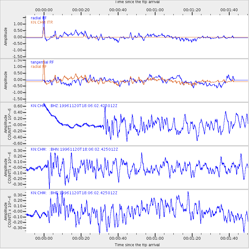
CHM KN.CHM - Earthquake Result Viewer
*The percent match for this event was below the threshold and hence no stack was calculated.
| Earthquake location: |
Luzon, Philippines |
| Earthquake latitude/longitude: |
16.3/120.5 |
| Earthquake time(UTC): |
1996/11/20 (325) 17:58:04 GMT |
| Earthquake Depth: |
33 km |
| Earthquake Magnitude: |
5.7 MB, 5.7 MS, 6.0 UNKNOWN, 5.9 MW |
| Earthquake Catalog/Contributor: |
WHDF/NEIC |
|
| Network: |
KN Kyrgyz Seismic Telemetry Network |
| Station: |
CHM KN.CHM |
| Lat/Lon: |
43.00 N/74.75 E |
| Elevation: |
655 m |
|
| Distance: |
47.1 deg |
| Az: |
314.087 deg |
| Baz: |
109.955 deg |
| Ray Param: |
$rayparam |
*The percent match for this event was below the threshold and hence was not used in the summary stack. |
|
| Radial Match: |
69.84392 % |
| Radial Bump: |
400 |
| Transverse Match: |
29.848158 % |
| Transverse Bump: |
400 |
| SOD ConfigId: |
4480 |
| Insert Time: |
2010-03-08 19:33:16.857 +0000 |
| GWidth: |
2.5 |
| Max Bumps: |
400 |
| Tol: |
0.001 |
|
Signal To Noise
| Channel | StoN | STA | LTA |
| KN:CHM: :BHN:19961120T18:06:02.425012Z | 6.35567 | 1.2739945E-7 | 2.0045006E-8 |
| KN:CHM: :BHE:19961120T18:06:02.425012Z | 0.5596157 | 1.0199177E-7 | 1.8225326E-7 |
| KN:CHM: :BHZ:19961120T18:06:02.425012Z | 1.093315 | 2.1857666E-7 | 1.9992102E-7 |
| Arrivals |
| Ps | |
| PpPs | |
| PsPs/PpSs | |


