You are here: Home > Network List > KN - Kyrgyz Seismic Telemetry Network Stations List
> Station CHM KN.CHM > Earthquake Result Viewer
CHM KN.CHM - Earthquake Result Viewer
*The percent match for this event was below the threshold and hence no stack was calculated.
| Earthquake location: |
Kuril Islands |
| Earthquake latitude/longitude: |
43.6/147.1 |
| Earthquake time(UTC): |
1994/10/18 (291) 17:12:51 GMT |
| Earthquake Depth: |
66 km |
| Earthquake Magnitude: |
6.1 MB, 6.1 UNKNOWN, 5.9 MW |
| Earthquake Catalog/Contributor: |
WHDF/NEIC |
|
| Network: |
KN Kyrgyz Seismic Telemetry Network |
| Station: |
CHM KN.CHM |
| Lat/Lon: |
43.00 N/74.75 E |
| Elevation: |
655 m |
|
| Distance: |
51.1 deg |
| Az: |
296.032 deg |
| Baz: |
62.931 deg |
| Ray Param: |
$rayparam |
*The percent match for this event was below the threshold and hence was not used in the summary stack. |
|
| Radial Match: |
74.90886 % |
| Radial Bump: |
400 |
| Transverse Match: |
70.77987 % |
| Transverse Bump: |
400 |
| SOD ConfigId: |
4480 |
| Insert Time: |
2010-03-08 19:33:20.953 +0000 |
| GWidth: |
2.5 |
| Max Bumps: |
400 |
| Tol: |
0.001 |
|
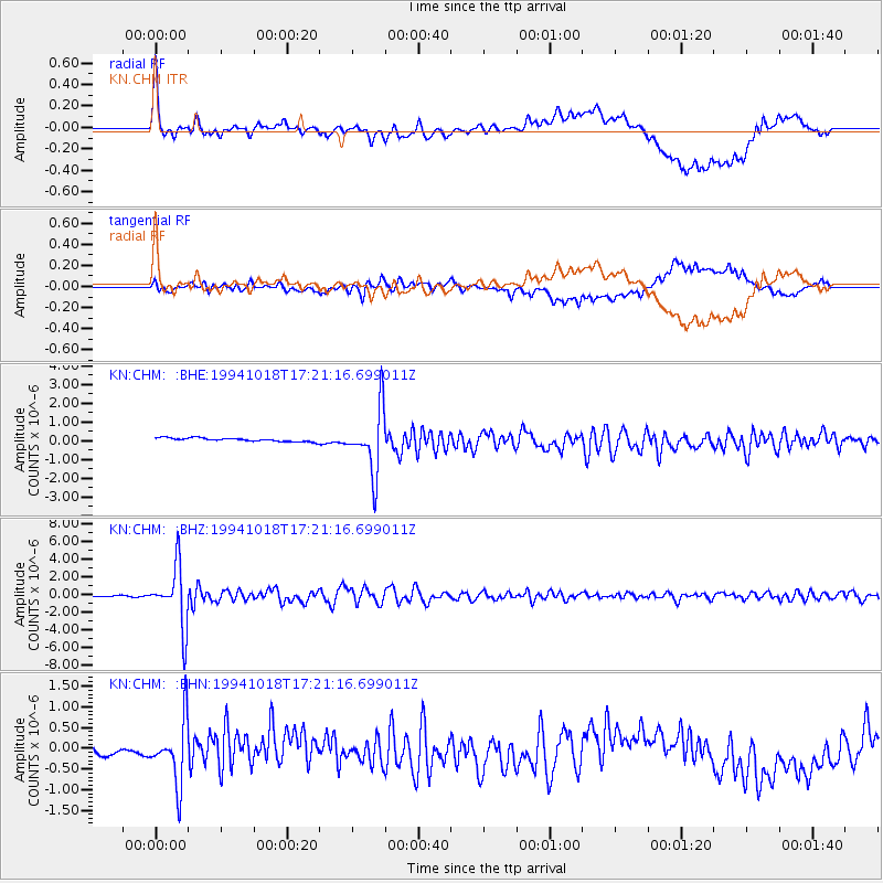
Signal To Noise
| Channel | StoN | STA | LTA |
| KN:CHM: :BHZ:19941018T17:21:16.699011Z | 43.607292 | 3.3773497E-6 | 7.7449194E-8 |
| KN:CHM: :BHN:19941018T17:21:16.699011Z | 8.242167 | 7.5601594E-7 | 9.1725376E-8 |
| KN:CHM: :BHE:19941018T17:21:16.699011Z | 17.900166 | 1.6979357E-6 | 9.4855864E-8 |
| Arrivals |
| Ps | |
| PpPs | |
| PsPs/PpSs | |


