You are here: Home > Network List > OX - North-East Italy Seismic Network Stations List
> Station FUSE Fusea > Earthquake Result Viewer
FUSE Fusea - Earthquake Result Viewer
| Earthquake location: |
Near East Coast Of Honshu, Japan |
| Earthquake latitude/longitude: |
38.9/141.9 |
| Earthquake time(UTC): |
2020/04/19 (110) 20:39:05 GMT |
| Earthquake Depth: |
38 km |
| Earthquake Magnitude: |
6.3 mww |
| Earthquake Catalog/Contributor: |
NEIC PDE/us |
|
| Network: |
OX North-East Italy Seismic Network |
| Station: |
FUSE Fusea |
| Lat/Lon: |
46.41 N/13.00 E |
| Elevation: |
520 m |
|
| Distance: |
83.5 deg |
| Az: |
327.204 deg |
| Baz: |
37.646 deg |
| Ray Param: |
0.04606273 |
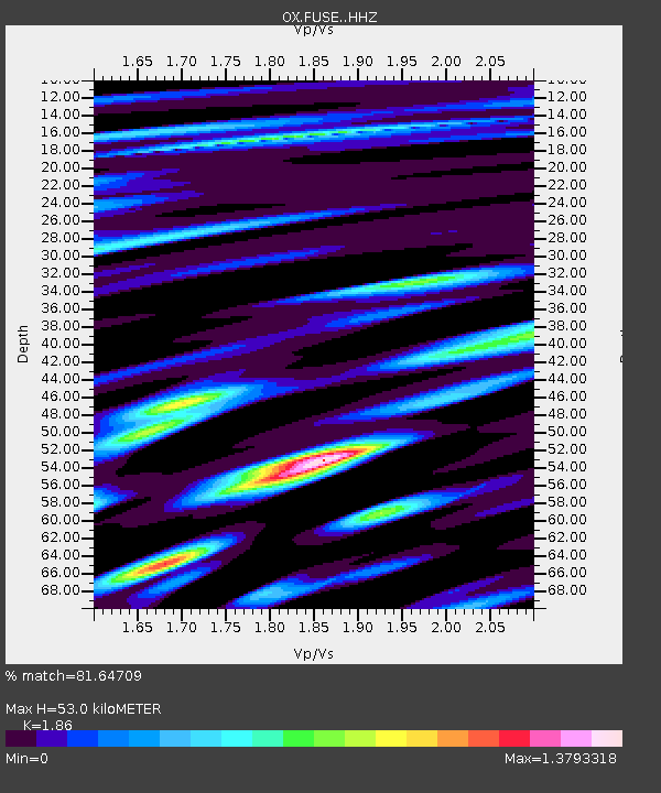
| Estimated Moho Depth: |
53.0 km |
| Estimated Crust Vp/Vs: |
1.86 |
| Assumed Crust Vp: |
6.35 km/s |
| Estimated Crust Vs: |
3.414 km/s |
| Estimated Crust Poisson's Ratio: |
0.30 |
|
| Radial Match: |
81.64709 % |
| Radial Bump: |
400 |
| Transverse Match: |
80.674644 % |
| Transverse Bump: |
400 |
| SOD ConfigId: |
21166931 |
| Insert Time: |
2020-05-03 21:00:05.895 +0000 |
| GWidth: |
2.5 |
| Max Bumps: |
400 |
| Tol: |
0.001 |
|

Signal To Noise
| Channel | StoN | STA | LTA |
| OX:FUSE: :HHZ:20200419T20:50:58.898001Z | 19.717117 | 1.0562445E-6 | 5.3569927E-8 |
| OX:FUSE: :HHN:20200419T20:50:58.898001Z | 5.1763835 | 4.3546947E-7 | 8.41262E-8 |
| OX:FUSE: :HHE:20200419T20:50:58.898001Z | 10.577247 | 3.866989E-7 | 3.6559506E-8 |
| Arrivals |
| Ps | 7.3 SECOND |
| PpPs | 23 SECOND |
| PsPs/PpSs | 31 SECOND |


