You are here: Home > Network List > OX - North-East Italy Seismic Network Stations List
> Station PRED Cave del Predil > Earthquake Result Viewer
PRED Cave del Predil - Earthquake Result Viewer
| Earthquake location: |
Near East Coast Of Honshu, Japan |
| Earthquake latitude/longitude: |
38.9/141.9 |
| Earthquake time(UTC): |
2020/04/19 (110) 20:39:05 GMT |
| Earthquake Depth: |
38 km |
| Earthquake Magnitude: |
6.3 mww |
| Earthquake Catalog/Contributor: |
NEIC PDE/us |
|
| Network: |
OX North-East Italy Seismic Network |
| Station: |
PRED Cave del Predil |
| Lat/Lon: |
46.44 N/13.56 E |
| Elevation: |
902 m |
|
| Distance: |
83.3 deg |
| Az: |
326.912 deg |
| Baz: |
38.019 deg |
| Ray Param: |
0.046248846 |
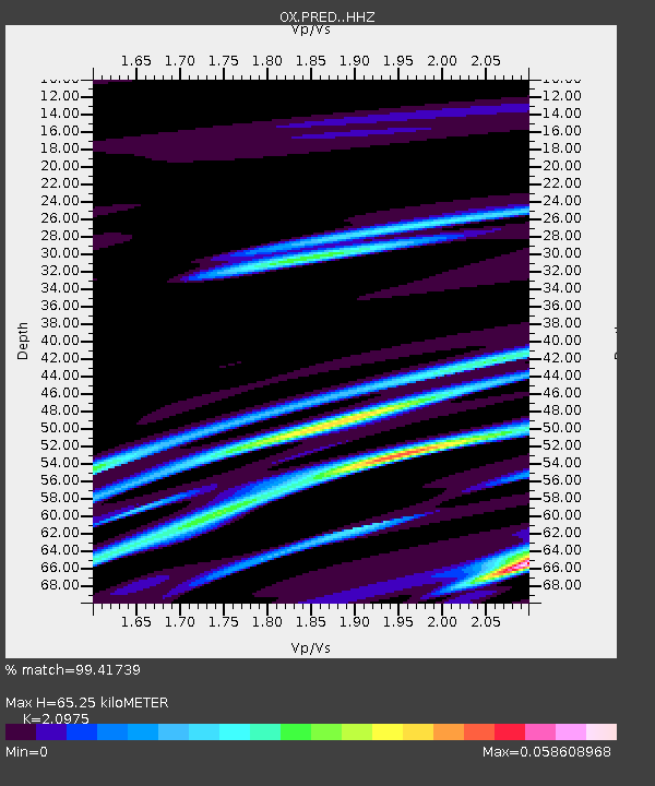
| Estimated Moho Depth: |
65.25 km |
| Estimated Crust Vp/Vs: |
2.10 |
| Assumed Crust Vp: |
6.35 km/s |
| Estimated Crust Vs: |
3.027 km/s |
| Estimated Crust Poisson's Ratio: |
0.35 |
|
| Radial Match: |
99.41739 % |
| Radial Bump: |
77 |
| Transverse Match: |
78.35753 % |
| Transverse Bump: |
400 |
| SOD ConfigId: |
21166931 |
| Insert Time: |
2020-05-03 21:00:08.129 +0000 |
| GWidth: |
2.5 |
| Max Bumps: |
400 |
| Tol: |
0.001 |
|

Signal To Noise
| Channel | StoN | STA | LTA |
| OX:PRED: :HHZ:20200419T20:50:57.557975Z | 14.943464 | 7.3625256E-7 | 4.92692E-8 |
| OX:PRED: :HHN:20200419T20:50:57.557975Z | 16.376413 | 5.0932107E-7 | 3.1100893E-8 |
| OX:PRED: :HHE:20200419T20:50:57.557975Z | 5.994679 | 3.2915818E-7 | 5.4908387E-8 |
| Arrivals |
| Ps | 12 SECOND |
| PpPs | 31 SECOND |
| PsPs/PpSs | 43 SECOND |


