You are here: Home > Network List > TA - USArray Transportable Network (new EarthScope stations) Stations List
> Station B22K Teshekpuk Lake, AK, USA > Earthquake Result Viewer
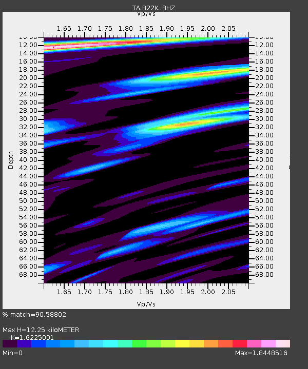
B22K Teshekpuk Lake, AK, USA - Earthquake Result Viewer
| Earthquake location: |
Near East Coast Of Honshu, Japan |
| Earthquake latitude/longitude: |
38.9/141.9 |
| Earthquake time(UTC): |
2020/04/19 (110) 20:39:05 GMT |
| Earthquake Depth: |
38 km |
| Earthquake Magnitude: |
6.3 mww |
| Earthquake Catalog/Contributor: |
NEIC PDE/us |
|
| Network: |
TA USArray Transportable Network (new EarthScope stations) |
| Station: |
B22K Teshekpuk Lake, AK, USA |
| Lat/Lon: |
70.34 N/153.42 W |
| Elevation: |
50 m |
|
| Distance: |
45.4 deg |
| Az: |
25.422 deg |
| Baz: |
261.719 deg |
| Ray Param: |
0.07119783 |
| Estimated Moho Depth: |
12.25 km |
| Estimated Crust Vp/Vs: |
1.62 |
| Assumed Crust Vp: |
5.738 km/s |
| Estimated Crust Vs: |
3.537 km/s |
| Estimated Crust Poisson's Ratio: |
0.19 |
|
| Radial Match: |
90.58802 % |
| Radial Bump: |
400 |
| Transverse Match: |
54.77157 % |
| Transverse Bump: |
400 |
| SOD ConfigId: |
21166931 |
| Insert Time: |
2020-05-03 21:01:59.407 +0000 |
| GWidth: |
2.5 |
| Max Bumps: |
400 |
| Tol: |
0.001 |
|

Signal To Noise
| Channel | StoN | STA | LTA |
| TA:B22K: :BHZ:20200419T20:46:50.649985Z | 12.639818 | 2.4590304E-6 | 1.9454635E-7 |
| TA:B22K: :BHN:20200419T20:46:50.649985Z | 1.356565 | 2.8016456E-7 | 2.0652497E-7 |
| TA:B22K: :BHE:20200419T20:46:50.649985Z | 6.960328 | 1.5015286E-6 | 2.157267E-7 |
| Arrivals |
| Ps | 1.4 SECOND |
| PpPs | 5.3 SECOND |
| PsPs/PpSs | 6.7 SECOND |


