You are here: Home > Network List > KN - Kyrgyz Seismic Telemetry Network Stations List
> Station CHM KN.CHM > Earthquake Result Viewer
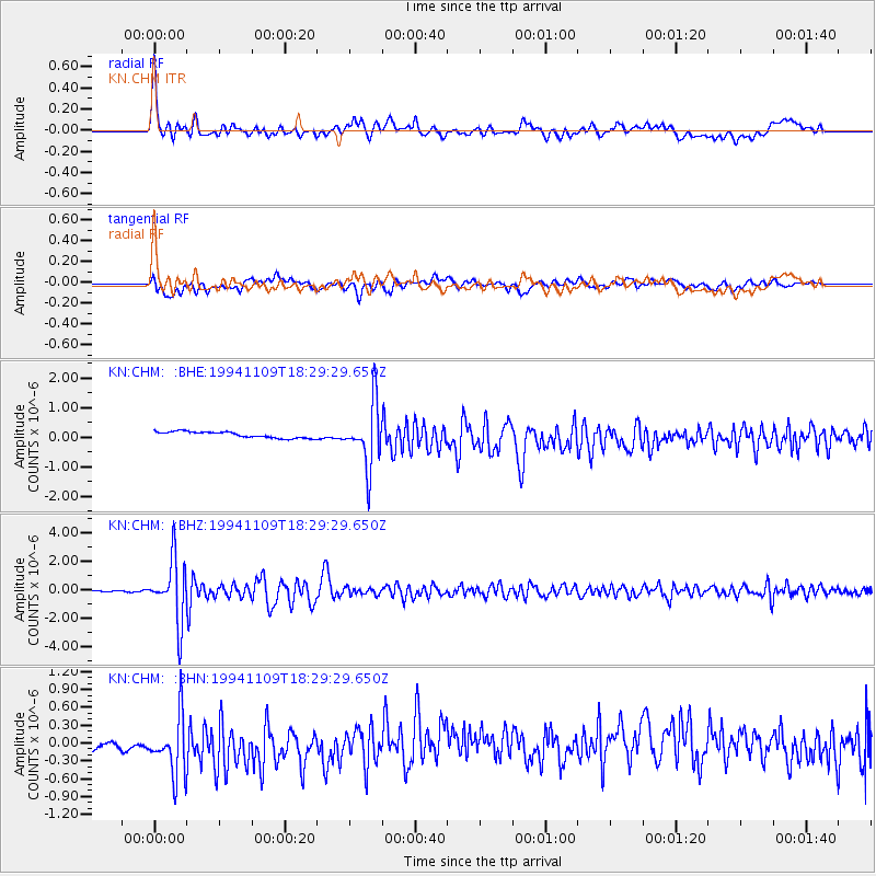
CHM KN.CHM - Earthquake Result Viewer
*The percent match for this event was below the threshold and hence no stack was calculated.
| Earthquake location: |
Kuril Islands |
| Earthquake latitude/longitude: |
43.5/147.2 |
| Earthquake time(UTC): |
1994/11/09 (313) 18:21:03 GMT |
| Earthquake Depth: |
61 km |
| Earthquake Magnitude: |
6.1 MB, 5.8 UNKNOWN, 5.8 MW |
| Earthquake Catalog/Contributor: |
WHDF/NEIC |
|
| Network: |
KN Kyrgyz Seismic Telemetry Network |
| Station: |
CHM KN.CHM |
| Lat/Lon: |
43.00 N/74.75 E |
| Elevation: |
655 m |
|
| Distance: |
51.1 deg |
| Az: |
296.082 deg |
| Baz: |
62.939 deg |
| Ray Param: |
$rayparam |
*The percent match for this event was below the threshold and hence was not used in the summary stack. |
|
| Radial Match: |
73.136475 % |
| Radial Bump: |
400 |
| Transverse Match: |
47.605156 % |
| Transverse Bump: |
400 |
| SOD ConfigId: |
4480 |
| Insert Time: |
2010-03-08 19:33:25.363 +0000 |
| GWidth: |
2.5 |
| Max Bumps: |
400 |
| Tol: |
0.001 |
|
Signal To Noise
| Channel | StoN | STA | LTA |
| KN:CHM: :BHZ:19941109T18:29:29.650Z | 45.719685 | 2.1601363E-6 | 4.7247404E-8 |
| KN:CHM: :BHN:19941109T18:29:29.650Z | 1.7682471 | 6.383669E-7 | 3.610168E-7 |
| KN:CHM: :BHE:19941109T18:29:29.650Z | 10.174776 | 1.0544982E-6 | 1.0363846E-7 |
| Arrivals |
| Ps | |
| PpPs | |
| PsPs/PpSs | |


