You are here: Home > Network List > TA - USArray Transportable Network (new EarthScope stations) Stations List
> Station F31M Tsiigehtchic, NWT, CAN > Earthquake Result Viewer
F31M Tsiigehtchic, NWT, CAN - Earthquake Result Viewer
| Earthquake location: |
Near East Coast Of Honshu, Japan |
| Earthquake latitude/longitude: |
38.9/141.9 |
| Earthquake time(UTC): |
2020/04/19 (110) 20:39:05 GMT |
| Earthquake Depth: |
38 km |
| Earthquake Magnitude: |
6.3 mww |
| Earthquake Catalog/Contributor: |
NEIC PDE/us |
|
| Network: |
TA USArray Transportable Network (new EarthScope stations) |
| Station: |
F31M Tsiigehtchic, NWT, CAN |
| Lat/Lon: |
67.44 N/133.74 W |
| Elevation: |
56 m |
|
| Distance: |
52.6 deg |
| Az: |
28.887 deg |
| Baz: |
282.366 deg |
| Ray Param: |
0.06655658 |
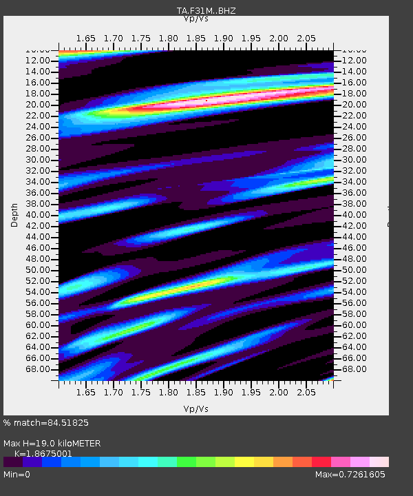
| Estimated Moho Depth: |
19.0 km |
| Estimated Crust Vp/Vs: |
1.87 |
| Assumed Crust Vp: |
6.171 km/s |
| Estimated Crust Vs: |
3.305 km/s |
| Estimated Crust Poisson's Ratio: |
0.30 |
|
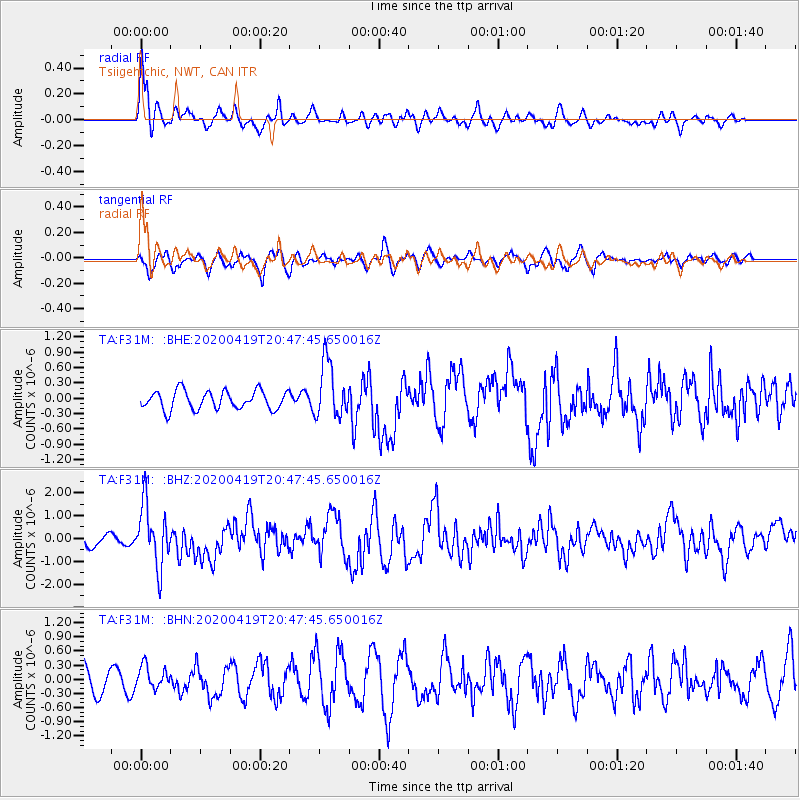
| Radial Match: |
84.51825 % |
| Radial Bump: |
400 |
| Transverse Match: |
60.827602 % |
| Transverse Bump: |
400 |
| SOD ConfigId: |
21166931 |
| Insert Time: |
2020-05-03 21:03:04.340 +0000 |
| GWidth: |
2.5 |
| Max Bumps: |
400 |
| Tol: |
0.001 |
|
Signal To Noise
| Channel | StoN | STA | LTA |
| TA:F31M: :BHZ:20200419T20:47:45.650016Z | 7.0134377 | 1.3319147E-6 | 1.8990897E-7 |
| TA:F31M: :BHN:20200419T20:47:45.650016Z | 0.60352695 | 2.434857E-7 | 4.0343795E-7 |
| TA:F31M: :BHE:20200419T20:47:45.650016Z | 3.0131626 | 5.448442E-7 | 1.8082137E-7 |
| Arrivals |
| Ps | 2.8 SECOND |
| PpPs | 8.4 SECOND |
| PsPs/PpSs | 11 SECOND |


