You are here: Home > Network List > TA - USArray Transportable Network (new EarthScope stations) Stations List
> Station G16K Koyuk River, AK, USA > Earthquake Result Viewer
G16K Koyuk River, AK, USA - Earthquake Result Viewer
| Earthquake location: |
Near East Coast Of Honshu, Japan |
| Earthquake latitude/longitude: |
38.9/141.9 |
| Earthquake time(UTC): |
2020/04/19 (110) 20:39:05 GMT |
| Earthquake Depth: |
38 km |
| Earthquake Magnitude: |
6.3 mww |
| Earthquake Catalog/Contributor: |
NEIC PDE/us |
|
| Network: |
TA USArray Transportable Network (new EarthScope stations) |
| Station: |
G16K Koyuk River, AK, USA |
| Lat/Lon: |
65.39 N/162.35 W |
| Elevation: |
169 m |
|
| Distance: |
41.2 deg |
| Az: |
31.663 deg |
| Baz: |
257.985 deg |
| Ray Param: |
0.0738409 |
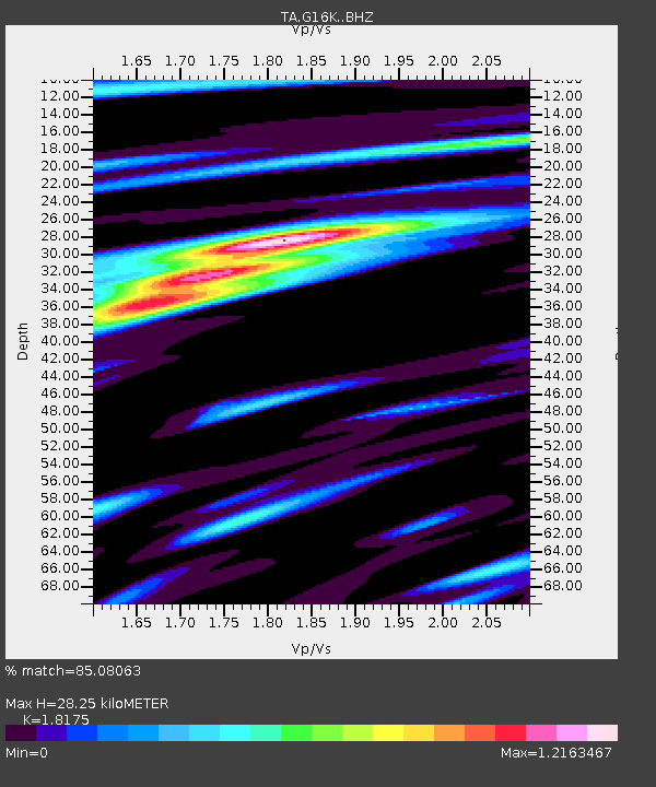
| Estimated Moho Depth: |
28.25 km |
| Estimated Crust Vp/Vs: |
1.82 |
| Assumed Crust Vp: |
6.276 km/s |
| Estimated Crust Vs: |
3.453 km/s |
| Estimated Crust Poisson's Ratio: |
0.28 |
|
| Radial Match: |
85.08063 % |
| Radial Bump: |
400 |
| Transverse Match: |
59.249954 % |
| Transverse Bump: |
400 |
| SOD ConfigId: |
21166931 |
| Insert Time: |
2020-05-03 21:03:07.250 +0000 |
| GWidth: |
2.5 |
| Max Bumps: |
400 |
| Tol: |
0.001 |
|

Signal To Noise
| Channel | StoN | STA | LTA |
| TA:G16K: :BHZ:20200419T20:46:16.749991Z | 11.7030115 | 1.1508442E-6 | 9.8337445E-8 |
| TA:G16K: :BHN:20200419T20:46:16.749991Z | 2.8720715 | 2.5329157E-7 | 8.819125E-8 |
| TA:G16K: :BHE:20200419T20:46:16.749991Z | 7.1299653 | 7.524364E-7 | 1.0553156E-7 |
| Arrivals |
| Ps | 3.9 SECOND |
| PpPs | 12 SECOND |
| PsPs/PpSs | 16 SECOND |


