You are here: Home > Network List > TA - USArray Transportable Network (new EarthScope stations) Stations List
> Station G21K Allakaket, AK, USA > Earthquake Result Viewer
G21K Allakaket, AK, USA - Earthquake Result Viewer

| Earthquake location: |
Near East Coast Of Honshu, Japan |
| Earthquake latitude/longitude: |
38.9/141.9 |
| Earthquake time(UTC): |
2020/04/19 (110) 20:39:05 GMT |
| Earthquake Depth: |
38 km |
| Earthquake Magnitude: |
6.3 mww |
| Earthquake Catalog/Contributor: |
NEIC PDE/us |
|
| Network: |
TA USArray Transportable Network (new EarthScope stations) |
| Station: |
G21K Allakaket, AK, USA |
| Lat/Lon: |
66.52 N/153.51 W |
| Elevation: |
446 m |
|
| Distance: |
45.0 deg |
| Az: |
30.8 deg |
| Baz: |
265.43 deg |
| Ray Param: |
0.07150444 |
| Estimated Moho Depth: |
20.0 km |
| Estimated Crust Vp/Vs: |
1.88 |
| Assumed Crust Vp: |
6.455 km/s |
| Estimated Crust Vs: |
3.429 km/s |
| Estimated Crust Poisson's Ratio: |
0.30 |
|
| Radial Match: |
88.09043 % |
| Radial Bump: |
400 |
| Transverse Match: |
76.378716 % |
| Transverse Bump: |
400 |
| SOD ConfigId: |
21166931 |
| Insert Time: |
2020-05-03 21:03:12.863 +0000 |
| GWidth: |
2.5 |
| Max Bumps: |
400 |
| Tol: |
0.001 |
|
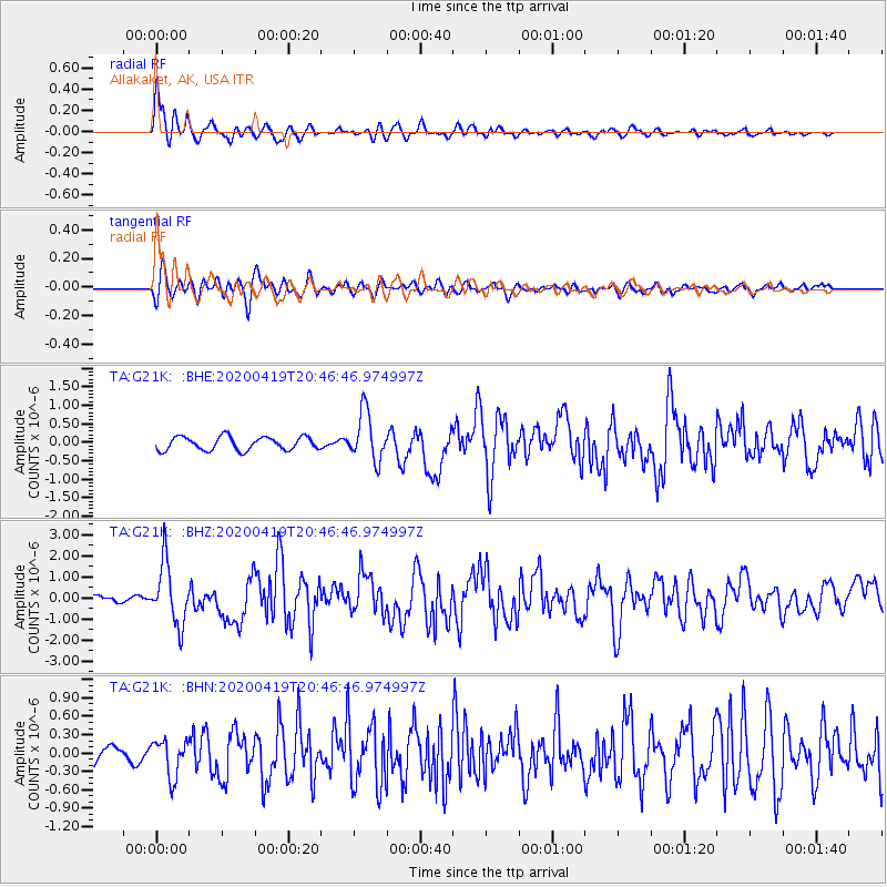
Signal To Noise
| Channel | StoN | STA | LTA |
| TA:G21K: :BHZ:20200419T20:46:46.974997Z | 9.031019 | 1.4490643E-6 | 1.6045414E-7 |
| TA:G21K: :BHN:20200419T20:46:46.974997Z | 2.3827138 | 3.0339507E-7 | 1.2733173E-7 |
| TA:G21K: :BHE:20200419T20:46:46.974997Z | 3.642542 | 6.570775E-7 | 1.8038982E-7 |
| Arrivals |
| Ps | 2.9 SECOND |
| PpPs | 8.4 SECOND |
| PsPs/PpSs | 11 SECOND |


