You are here: Home > Network List > TA - USArray Transportable Network (new EarthScope stations) Stations List
> Station O28M Mount Upton, YT, CAN > Earthquake Result Viewer
O28M Mount Upton, YT, CAN - Earthquake Result Viewer
| Earthquake location: |
Near East Coast Of Honshu, Japan |
| Earthquake latitude/longitude: |
38.9/141.9 |
| Earthquake time(UTC): |
2020/04/19 (110) 20:39:05 GMT |
| Earthquake Depth: |
38 km |
| Earthquake Magnitude: |
6.3 mww |
| Earthquake Catalog/Contributor: |
NEIC PDE/us |
|
| Network: |
TA USArray Transportable Network (new EarthScope stations) |
| Station: |
O28M Mount Upton, YT, CAN |
| Lat/Lon: |
60.77 N/140.19 W |
| Elevation: |
2622 m |
|
| Distance: |
51.3 deg |
| Az: |
37.95 deg |
| Baz: |
282.154 deg |
| Ray Param: |
0.06743692 |
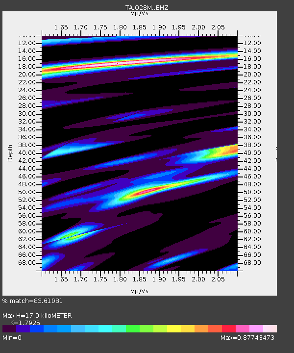
| Estimated Moho Depth: |
17.0 km |
| Estimated Crust Vp/Vs: |
1.79 |
| Assumed Crust Vp: |
6.566 km/s |
| Estimated Crust Vs: |
3.663 km/s |
| Estimated Crust Poisson's Ratio: |
0.27 |
|
| Radial Match: |
83.61081 % |
| Radial Bump: |
359 |
| Transverse Match: |
63.49323 % |
| Transverse Bump: |
400 |
| SOD ConfigId: |
21166931 |
| Insert Time: |
2020-05-03 21:04:36.650 +0000 |
| GWidth: |
2.5 |
| Max Bumps: |
400 |
| Tol: |
0.001 |
|
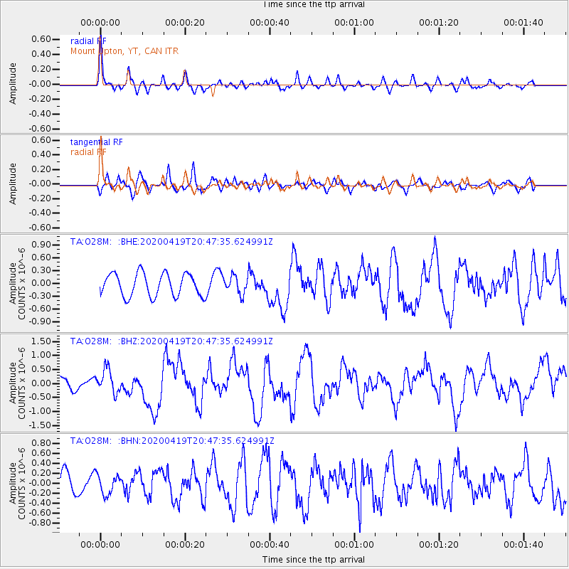
Signal To Noise
| Channel | StoN | STA | LTA |
| TA:O28M: :BHZ:20200419T20:47:35.624991Z | 2.6752017 | 4.3524182E-7 | 1.6269495E-7 |
| TA:O28M: :BHN:20200419T20:47:35.624991Z | 0.64799684 | 1.9080674E-7 | 2.944563E-7 |
| TA:O28M: :BHE:20200419T20:47:35.624991Z | 0.77216333 | 2.0512047E-7 | 2.656439E-7 |
| Arrivals |
| Ps | 2.2 SECOND |
| PpPs | 6.8 SECOND |
| PsPs/PpSs | 9.0 SECOND |


