You are here: Home > Network List > TX - Texas Seismological Network Stations List
> Station WTFS Witchita Falls > Earthquake Result Viewer
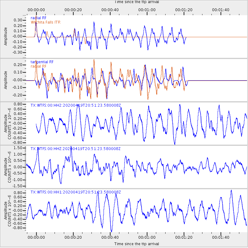
WTFS Witchita Falls - Earthquake Result Viewer
*The percent match for this event was below the threshold and hence no stack was calculated.
| Earthquake location: |
Near East Coast Of Honshu, Japan |
| Earthquake latitude/longitude: |
38.9/141.9 |
| Earthquake time(UTC): |
2020/04/19 (110) 20:39:05 GMT |
| Earthquake Depth: |
38 km |
| Earthquake Magnitude: |
6.3 mww |
| Earthquake Catalog/Contributor: |
NEIC PDE/us |
|
| Network: |
TX Texas Seismological Network |
| Station: |
WTFS Witchita Falls |
| Lat/Lon: |
33.77 N/98.46 W |
| Elevation: |
277 m |
|
| Distance: |
88.6 deg |
| Az: |
46.429 deg |
| Baz: |
317.27 deg |
| Ray Param: |
$rayparam |
*The percent match for this event was below the threshold and hence was not used in the summary stack. |
|
| Radial Match: |
51.827824 % |
| Radial Bump: |
331 |
| Transverse Match: |
62.905243 % |
| Transverse Bump: |
305 |
| SOD ConfigId: |
21166931 |
| Insert Time: |
2020-05-03 21:06:14.873 +0000 |
| GWidth: |
2.5 |
| Max Bumps: |
400 |
| Tol: |
0.001 |
|
Signal To Noise
| Channel | StoN | STA | LTA |
| TX:WTFS:00:HHZ:20200419T20:51:23.580008Z | 3.3207266 | 6.288307E-7 | 1.893654E-7 |
| TX:WTFS:00:HH1:20200419T20:51:23.580008Z | 0.574891 | 1.4325153E-7 | 2.4918032E-7 |
| TX:WTFS:00:HH2:20200419T20:51:23.580008Z | 0.8727591 | 2.7425608E-7 | 3.142403E-7 |
| Arrivals |
| Ps | |
| PpPs | |
| PsPs/PpSs | |


