You are here: Home > Network List > US - United States National Seismic Network Stations List
> Station EGMT Eagleton, Montana, USA > Earthquake Result Viewer
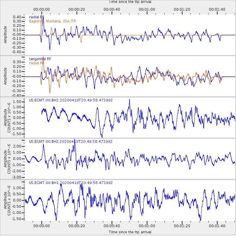
EGMT Eagleton, Montana, USA - Earthquake Result Viewer
*The percent match for this event was below the threshold and hence no stack was calculated.
| Earthquake location: |
Near East Coast Of Honshu, Japan |
| Earthquake latitude/longitude: |
38.9/141.9 |
| Earthquake time(UTC): |
2020/04/19 (110) 20:39:05 GMT |
| Earthquake Depth: |
38 km |
| Earthquake Magnitude: |
6.3 mww |
| Earthquake Catalog/Contributor: |
NEIC PDE/us |
|
| Network: |
US United States National Seismic Network |
| Station: |
EGMT Eagleton, Montana, USA |
| Lat/Lon: |
48.02 N/109.75 W |
| Elevation: |
1055 m |
|
| Distance: |
72.6 deg |
| Az: |
41.903 deg |
| Baz: |
309.087 deg |
| Ray Param: |
$rayparam |
*The percent match for this event was below the threshold and hence was not used in the summary stack. |
|
| Radial Match: |
66.95325 % |
| Radial Bump: |
400 |
| Transverse Match: |
54.357212 % |
| Transverse Bump: |
400 |
| SOD ConfigId: |
21166931 |
| Insert Time: |
2020-05-03 21:07:07.031 +0000 |
| GWidth: |
2.5 |
| Max Bumps: |
400 |
| Tol: |
0.001 |
|
Signal To Noise
| Channel | StoN | STA | LTA |
| US:EGMT:00:BHZ:20200419T20:49:58.47399Z | 3.2517607 | 9.357315E-7 | 2.8776148E-7 |
| US:EGMT:00:BH1:20200419T20:49:58.47399Z | 1.5725108 | 5.12741E-7 | 3.2606516E-7 |
| US:EGMT:00:BH2:20200419T20:49:58.47399Z | 3.4277904 | 1.1828292E-6 | 3.4507045E-7 |
| Arrivals |
| Ps | |
| PpPs | |
| PsPs/PpSs | |


