You are here: Home > Network List > US - United States National Seismic Network Stations List
> Station MNTX Cornudas Mountains, Texas, USA > Earthquake Result Viewer
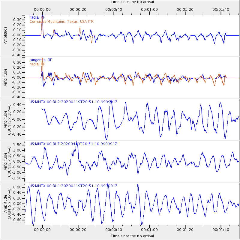
MNTX Cornudas Mountains, Texas, USA - Earthquake Result Viewer
*The percent match for this event was below the threshold and hence no stack was calculated.
| Earthquake location: |
Near East Coast Of Honshu, Japan |
| Earthquake latitude/longitude: |
38.9/141.9 |
| Earthquake time(UTC): |
2020/04/19 (110) 20:39:05 GMT |
| Earthquake Depth: |
38 km |
| Earthquake Magnitude: |
6.3 mww |
| Earthquake Catalog/Contributor: |
NEIC PDE/us |
|
| Network: |
US United States National Seismic Network |
| Station: |
MNTX Cornudas Mountains, Texas, USA |
| Lat/Lon: |
31.70 N/105.38 W |
| Elevation: |
404 m |
|
| Distance: |
86.0 deg |
| Az: |
52.038 deg |
| Baz: |
313.812 deg |
| Ray Param: |
$rayparam |
*The percent match for this event was below the threshold and hence was not used in the summary stack. |
|
| Radial Match: |
47.96821 % |
| Radial Bump: |
305 |
| Transverse Match: |
44.047333 % |
| Transverse Bump: |
400 |
| SOD ConfigId: |
21166931 |
| Insert Time: |
2020-05-03 21:07:24.277 +0000 |
| GWidth: |
2.5 |
| Max Bumps: |
400 |
| Tol: |
0.001 |
|
Signal To Noise
| Channel | StoN | STA | LTA |
| US:MNTX:00:BHZ:20200419T20:51:10.999991Z | 5.5657363 | 6.597747E-7 | 1.1854222E-7 |
| US:MNTX:00:BH1:20200419T20:51:10.999991Z | 1.0172065 | 3.3398015E-7 | 3.283307E-7 |
| US:MNTX:00:BH2:20200419T20:51:10.999991Z | 1.5317099 | 2.2725472E-7 | 1.4836668E-7 |
| Arrivals |
| Ps | |
| PpPs | |
| PsPs/PpSs | |


