You are here: Home > Network List > UU - University of Utah Regional Network Stations List
> Station FORU South Mineral Mountains, UT, USA > Earthquake Result Viewer
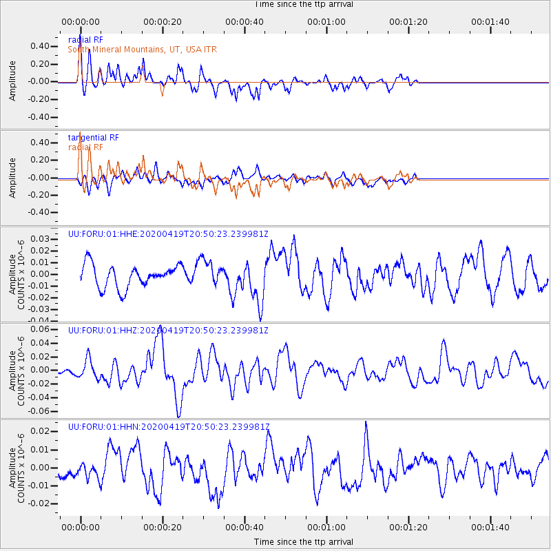
FORU South Mineral Mountains, UT, USA - Earthquake Result Viewer
*The percent match for this event was below the threshold and hence no stack was calculated.
| Earthquake location: |
Near East Coast Of Honshu, Japan |
| Earthquake latitude/longitude: |
38.9/141.9 |
| Earthquake time(UTC): |
2020/04/19 (110) 20:39:05 GMT |
| Earthquake Depth: |
38 km |
| Earthquake Magnitude: |
6.3 mww |
| Earthquake Catalog/Contributor: |
NEIC PDE/us |
|
| Network: |
UU University of Utah Regional Network |
| Station: |
FORU South Mineral Mountains, UT, USA |
| Lat/Lon: |
38.46 N/112.86 W |
| Elevation: |
1840 m |
|
| Distance: |
76.9 deg |
| Az: |
51.066 deg |
| Baz: |
309.376 deg |
| Ray Param: |
$rayparam |
*The percent match for this event was below the threshold and hence was not used in the summary stack. |
|
| Radial Match: |
56.074833 % |
| Radial Bump: |
400 |
| Transverse Match: |
56.92355 % |
| Transverse Bump: |
400 |
| SOD ConfigId: |
21166931 |
| Insert Time: |
2020-05-03 21:07:57.154 +0000 |
| GWidth: |
2.5 |
| Max Bumps: |
400 |
| Tol: |
0.001 |
|
Signal To Noise
| Channel | StoN | STA | LTA |
| UU:FORU:01:HHZ:20200419T20:50:23.239981Z | 1.8013829 | 1.45913805E-8 | 8.100099E-9 |
| UU:FORU:01:HHN:20200419T20:50:23.239981Z | 0.7436479 | 3.6988648E-9 | 4.9739466E-9 |
| UU:FORU:01:HHE:20200419T20:50:23.239981Z | 1.1575303 | 1.1117414E-8 | 9.604426E-9 |
| Arrivals |
| Ps | |
| PpPs | |
| PsPs/PpSs | |


