You are here: Home > Network List > UW - Pacific Northwest Regional Seismic Network Stations List
> Station UMAT Pilot Rock, OR, USA > Earthquake Result Viewer
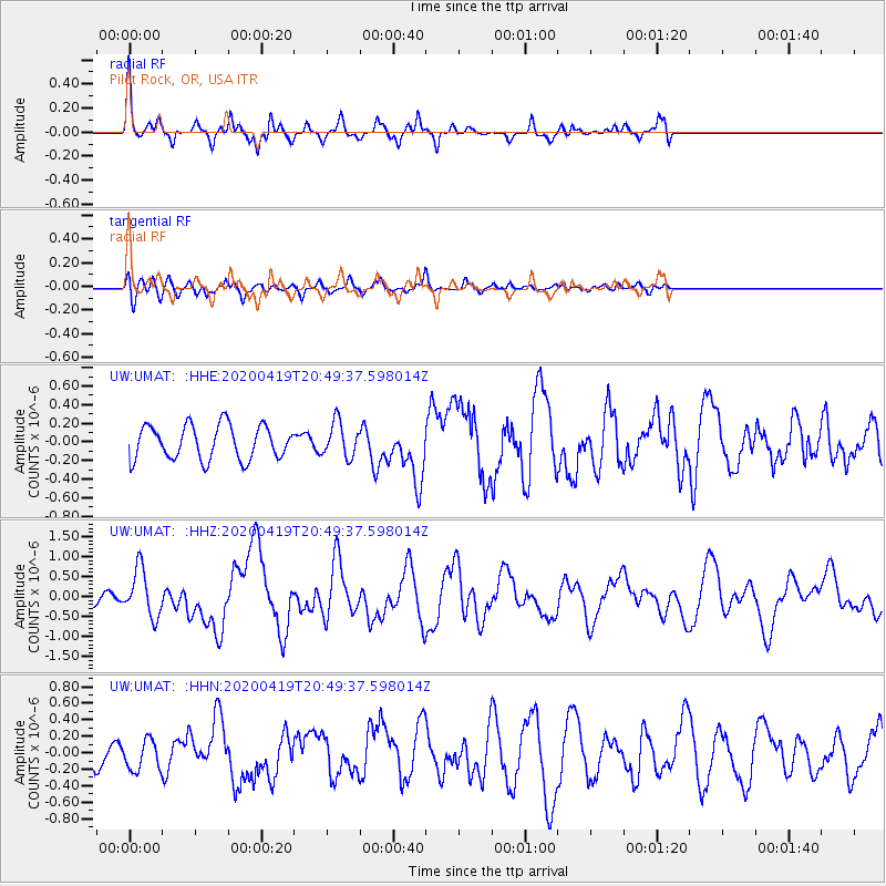
UMAT Pilot Rock, OR, USA - Earthquake Result Viewer
*The percent match for this event was below the threshold and hence no stack was calculated.
| Earthquake location: |
Near East Coast Of Honshu, Japan |
| Earthquake latitude/longitude: |
38.9/141.9 |
| Earthquake time(UTC): |
2020/04/19 (110) 20:39:05 GMT |
| Earthquake Depth: |
38 km |
| Earthquake Magnitude: |
6.3 mww |
| Earthquake Catalog/Contributor: |
NEIC PDE/us |
|
| Network: |
UW Pacific Northwest Regional Seismic Network |
| Station: |
UMAT Pilot Rock, OR, USA |
| Lat/Lon: |
45.29 N/118.96 W |
| Elevation: |
1318 m |
|
| Distance: |
69.2 deg |
| Az: |
48.231 deg |
| Baz: |
304.482 deg |
| Ray Param: |
$rayparam |
*The percent match for this event was below the threshold and hence was not used in the summary stack. |
|
| Radial Match: |
79.51034 % |
| Radial Bump: |
289 |
| Transverse Match: |
62.264713 % |
| Transverse Bump: |
400 |
| SOD ConfigId: |
21166931 |
| Insert Time: |
2020-05-03 21:09:27.027 +0000 |
| GWidth: |
2.5 |
| Max Bumps: |
400 |
| Tol: |
0.001 |
|
Signal To Noise
| Channel | StoN | STA | LTA |
| UW:UMAT: :HHZ:20200419T20:49:37.598014Z | 2.9782903 | 5.9371314E-7 | 1.9934696E-7 |
| UW:UMAT: :HHN:20200419T20:49:37.598014Z | 0.6882812 | 1.8003493E-7 | 2.6157176E-7 |
| UW:UMAT: :HHE:20200419T20:49:37.598014Z | 1.0251311 | 1.8701554E-7 | 1.8243085E-7 |
| Arrivals |
| Ps | |
| PpPs | |
| PsPs/PpSs | |


