You are here: Home > Network List > TA - USArray Transportable Network (new EarthScope stations) Stations List
> Station E18K Tukpahlearik Creek, AK, USA > Earthquake Result Viewer
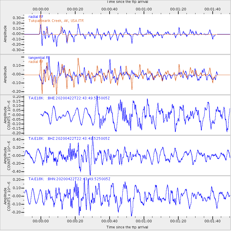
E18K Tukpahlearik Creek, AK, USA - Earthquake Result Viewer
*The percent match for this event was below the threshold and hence no stack was calculated.
| Earthquake location: |
Tonga Islands Region |
| Earthquake latitude/longitude: |
-22.1/-175.5 |
| Earthquake time(UTC): |
2020/04/22 (113) 22:31:25 GMT |
| Earthquake Depth: |
40 km |
| Earthquake Magnitude: |
5.5 Mww |
| Earthquake Catalog/Contributor: |
NEIC PDE/us |
|
| Network: |
TA USArray Transportable Network (new EarthScope stations) |
| Station: |
E18K Tukpahlearik Creek, AK, USA |
| Lat/Lon: |
67.42 N/160.60 W |
| Elevation: |
297 m |
|
| Distance: |
89.9 deg |
| Az: |
5.696 deg |
| Baz: |
193.791 deg |
| Ray Param: |
$rayparam |
*The percent match for this event was below the threshold and hence was not used in the summary stack. |
|
| Radial Match: |
54.563927 % |
| Radial Bump: |
400 |
| Transverse Match: |
60.18255 % |
| Transverse Bump: |
400 |
| SOD ConfigId: |
21166931 |
| Insert Time: |
2020-05-06 22:43:46.430 +0000 |
| GWidth: |
2.5 |
| Max Bumps: |
400 |
| Tol: |
0.001 |
|
Signal To Noise
| Channel | StoN | STA | LTA |
| TA:E18K: :BHZ:20200422T22:43:49.525005Z | 1.5392874 | 1.1336007E-7 | 7.3644514E-8 |
| TA:E18K: :BHN:20200422T22:43:49.525005Z | 1.1928638 | 6.071306E-8 | 5.0896894E-8 |
| TA:E18K: :BHE:20200422T22:43:49.525005Z | 2.15856 | 1.0213686E-7 | 4.7317126E-8 |
| Arrivals |
| Ps | |
| PpPs | |
| PsPs/PpSs | |


