You are here: Home > Network List > UW - Pacific Northwest Regional Seismic Network Stations List
> Station HOOD Mt Hood Meadows, OR CREST BB SMO > Earthquake Result Viewer
HOOD Mt Hood Meadows, OR CREST BB SMO - Earthquake Result Viewer
*The percent match for this event was below the threshold and hence no stack was calculated.
| Earthquake location: |
Tonga Islands Region |
| Earthquake latitude/longitude: |
-22.1/-175.5 |
| Earthquake time(UTC): |
2020/04/22 (113) 22:31:25 GMT |
| Earthquake Depth: |
40 km |
| Earthquake Magnitude: |
5.5 Mww |
| Earthquake Catalog/Contributor: |
NEIC PDE/us |
|
| Network: |
UW Pacific Northwest Regional Seismic Network |
| Station: |
HOOD Mt Hood Meadows, OR CREST BB SMO |
| Lat/Lon: |
45.32 N/121.65 W |
| Elevation: |
1520 m |
|
| Distance: |
83.0 deg |
| Az: |
35.02 deg |
| Baz: |
228.976 deg |
| Ray Param: |
$rayparam |
*The percent match for this event was below the threshold and hence was not used in the summary stack. |
|
| Radial Match: |
25.697496 % |
| Radial Bump: |
400 |
| Transverse Match: |
28.937609 % |
| Transverse Bump: |
400 |
| SOD ConfigId: |
21166931 |
| Insert Time: |
2020-05-06 22:46:57.078 +0000 |
| GWidth: |
2.5 |
| Max Bumps: |
400 |
| Tol: |
0.001 |
|
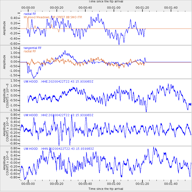
Signal To Noise
| Channel | StoN | STA | LTA |
| UW:HOOD: :HHZ:20200422T22:43:15.939983Z | 1.4418377 | 2.4998025E-7 | 1.7337612E-7 |
| UW:HOOD: :HHN:20200422T22:43:15.939983Z | 1.2156239 | 7.924194E-7 | 6.5186236E-7 |
| UW:HOOD: :HHE:20200422T22:43:15.939983Z | 3.9624684 | 8.7453E-7 | 2.2070333E-7 |
| Arrivals |
| Ps | |
| PpPs | |
| PsPs/PpSs | |


