You are here: Home > Network List > KN - Kyrgyz Seismic Telemetry Network Stations List
> Station CHM KN.CHM > Earthquake Result Viewer
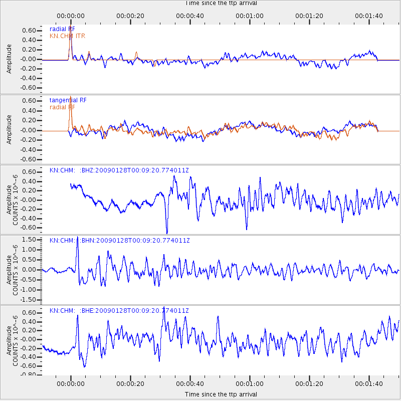
CHM KN.CHM - Earthquake Result Viewer
*The percent match for this event was below the threshold and hence no stack was calculated.
| Earthquake location: |
Southern Sumatra, Indonesia |
| Earthquake latitude/longitude: |
-0.3/98.3 |
| Earthquake time(UTC): |
2009/01/28 (028) 00:01:13 GMT |
| Earthquake Depth: |
14 km |
| Earthquake Magnitude: |
5.7 MB, 5.6 MS, 5.7 MW, 5.7 MW |
| Earthquake Catalog/Contributor: |
WHDF/NEIC |
|
| Network: |
KN Kyrgyz Seismic Telemetry Network |
| Station: |
CHM KN.CHM |
| Lat/Lon: |
43.00 N/74.75 E |
| Elevation: |
655 m |
|
| Distance: |
48.0 deg |
| Az: |
336.783 deg |
| Baz: |
147.498 deg |
| Ray Param: |
$rayparam |
*The percent match for this event was below the threshold and hence was not used in the summary stack. |
|
| Radial Match: |
35.344025 % |
| Radial Bump: |
400 |
| Transverse Match: |
27.805067 % |
| Transverse Bump: |
400 |
| SOD ConfigId: |
2658 |
| Insert Time: |
2010-03-08 19:34:47.208 +0000 |
| GWidth: |
2.5 |
| Max Bumps: |
400 |
| Tol: |
0.001 |
|
Signal To Noise
| Channel | StoN | STA | LTA |
| KN:CHM: :BHN:20090128T00:09:20.774011Z | 6.819251 | 5.899071E-7 | 8.6506134E-8 |
| KN:CHM: :BHE:20090128T00:09:20.774011Z | 1.2832341 | 5.366639E-7 | 4.1821198E-7 |
| KN:CHM: :BHZ:20090128T00:09:20.774011Z | 1.8178015 | 3.0180883E-7 | 1.6602958E-7 |
| Arrivals |
| Ps | |
| PpPs | |
| PsPs/PpSs | |


