You are here: Home > Network List > KN - Kyrgyz Seismic Telemetry Network Stations List
> Station CHM KN.CHM > Earthquake Result Viewer
CHM KN.CHM - Earthquake Result Viewer
*The percent match for this event was below the threshold and hence no stack was calculated.
| Earthquake location: |
Minahassa Peninsula, Sulawesi |
| Earthquake latitude/longitude: |
-0.0/122.9 |
| Earthquake time(UTC): |
1996/08/01 (214) 04:08:23 GMT |
| Earthquake Depth: |
149 km |
| Earthquake Magnitude: |
5.5 MB, 5.6 UNKNOWN, 5.5 MW |
| Earthquake Catalog/Contributor: |
WHDF/NEIC |
|
| Network: |
KN Kyrgyz Seismic Telemetry Network |
| Station: |
CHM KN.CHM |
| Lat/Lon: |
43.00 N/74.75 E |
| Elevation: |
655 m |
|
| Distance: |
60.7 deg |
| Az: |
321.183 deg |
| Baz: |
121.305 deg |
| Ray Param: |
$rayparam |
*The percent match for this event was below the threshold and hence was not used in the summary stack. |
|
| Radial Match: |
67.02929 % |
| Radial Bump: |
400 |
| Transverse Match: |
57.566032 % |
| Transverse Bump: |
400 |
| SOD ConfigId: |
4480 |
| Insert Time: |
2010-03-08 19:34:53.260 +0000 |
| GWidth: |
2.5 |
| Max Bumps: |
400 |
| Tol: |
0.001 |
|
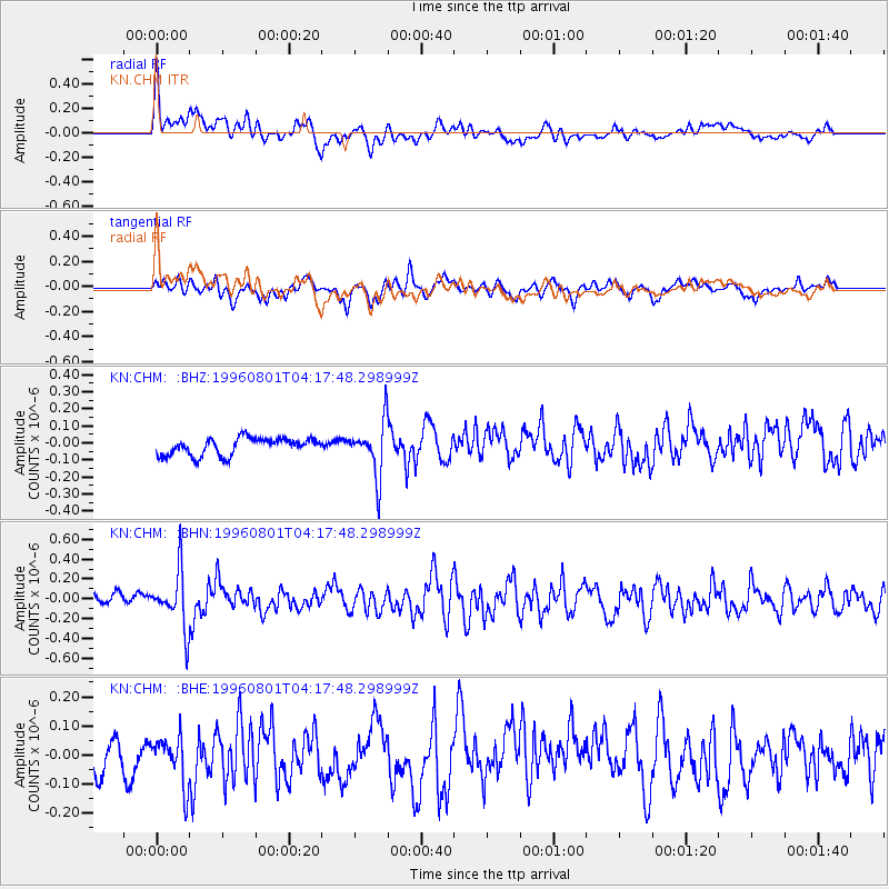
Signal To Noise
| Channel | StoN | STA | LTA |
| KN:CHM: :BHN:19960801T04:17:48.298999Z | 5.018222 | 2.8414306E-7 | 5.662226E-8 |
| KN:CHM: :BHE:19960801T04:17:48.298999Z | 1.8102063 | 8.455276E-8 | 4.670891E-8 |
| KN:CHM: :BHZ:19960801T04:17:48.298999Z | 3.1658885 | 1.584912E-7 | 5.0062155E-8 |
| Arrivals |
| Ps | |
| PpPs | |
| PsPs/PpSs | |


