You are here: Home > Network List > TS - TERRAscope (Southern California Seismic Network) Stations List
> Station SBC Santa Barbara, California, USA > Earthquake Result Viewer
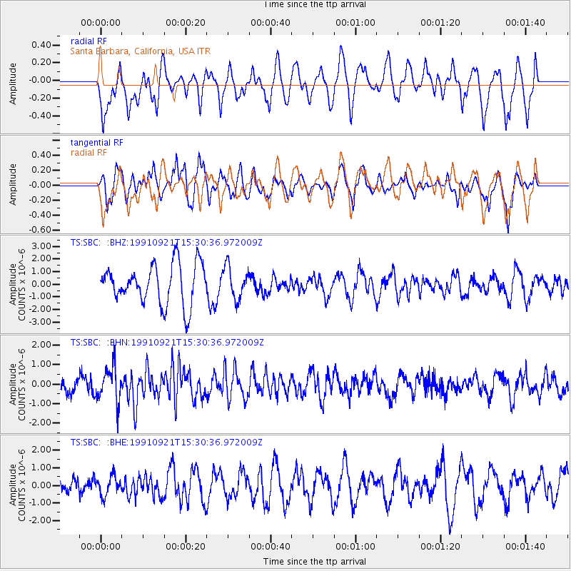
SBC Santa Barbara, California, USA - Earthquake Result Viewer
*The percent match for this event was below the threshold and hence no stack was calculated.
| Earthquake location: |
Tonga Islands |
| Earthquake latitude/longitude: |
-16.2/-173.1 |
| Earthquake time(UTC): |
1991/09/21 (264) 15:19:50 GMT |
| Earthquake Depth: |
33 km |
| Earthquake Magnitude: |
5.9 MB, 5.7 MS |
| Earthquake Catalog/Contributor: |
WHDF/NEIC |
|
| Network: |
TS TERRAscope (Southern California Seismic Network) |
| Station: |
SBC Santa Barbara, California, USA |
| Lat/Lon: |
34.44 N/119.71 W |
| Elevation: |
90 m |
|
| Distance: |
71.5 deg |
| Az: |
44.417 deg |
| Baz: |
234.466 deg |
| Ray Param: |
$rayparam |
*The percent match for this event was below the threshold and hence was not used in the summary stack. |
|
| Radial Match: |
51.46539 % |
| Radial Bump: |
400 |
| Transverse Match: |
65.238716 % |
| Transverse Bump: |
373 |
| SOD ConfigId: |
4480 |
| Insert Time: |
2010-02-26 14:48:38.196 +0000 |
| GWidth: |
2.5 |
| Max Bumps: |
400 |
| Tol: |
0.001 |
|
Signal To Noise
| Channel | StoN | STA | LTA |
| TS:SBC: :BHN:19910921T15:30:36.972009Z | 2.1416585 | 9.042098E-7 | 4.2220074E-7 |
| TS:SBC: :BHE:19910921T15:30:36.972009Z | 1.0082682 | 5.5616243E-7 | 5.516017E-7 |
| TS:SBC: :BHZ:19910921T15:30:36.972009Z | 0.80836904 | 1.288255E-6 | 1.5936472E-6 |
| Arrivals |
| Ps | |
| PpPs | |
| PsPs/PpSs | |


