You are here: Home > Network List > KN - Kyrgyz Seismic Telemetry Network Stations List
> Station CHM KN.CHM > Earthquake Result Viewer
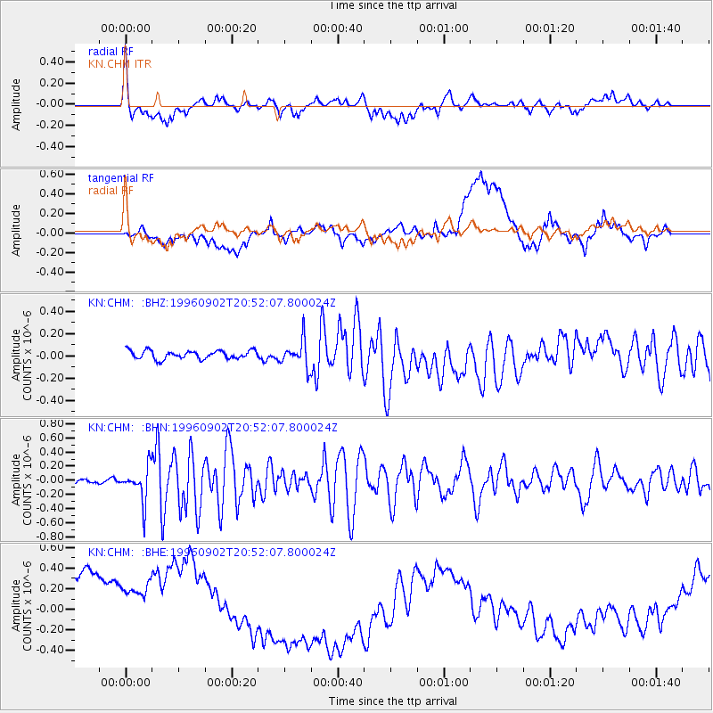
CHM KN.CHM - Earthquake Result Viewer
*The percent match for this event was below the threshold and hence no stack was calculated.
| Earthquake location: |
South Of Mariana Islands |
| Earthquake latitude/longitude: |
12.3/143.8 |
| Earthquake time(UTC): |
1996/09/02 (246) 20:41:52 GMT |
| Earthquake Depth: |
33 km |
| Earthquake Magnitude: |
5.7 MB, 5.7 MS, 5.9 UNKNOWN, 5.8 MW |
| Earthquake Catalog/Contributor: |
WHDF/NEIC |
|
| Network: |
KN Kyrgyz Seismic Telemetry Network |
| Station: |
CHM KN.CHM |
| Lat/Lon: |
43.00 N/74.75 E |
| Elevation: |
655 m |
|
| Distance: |
66.4 deg |
| Az: |
311.607 deg |
| Baz: |
95.123 deg |
| Ray Param: |
$rayparam |
*The percent match for this event was below the threshold and hence was not used in the summary stack. |
|
| Radial Match: |
69.45629 % |
| Radial Bump: |
400 |
| Transverse Match: |
9.866788 % |
| Transverse Bump: |
400 |
| SOD ConfigId: |
4480 |
| Insert Time: |
2010-03-08 19:35:22.721 +0000 |
| GWidth: |
2.5 |
| Max Bumps: |
400 |
| Tol: |
0.001 |
|
Signal To Noise
| Channel | StoN | STA | LTA |
| KN:CHM: :BHN:19960902T20:52:07.800024Z | 7.7380915 | 2.4601783E-7 | 3.179309E-8 |
| KN:CHM: :BHE:19960902T20:52:07.800024Z | 0.75726 | 6.216269E-7 | 8.208896E-7 |
| KN:CHM: :BHZ:19960902T20:52:07.800024Z | 3.2584205 | 1.2184147E-7 | 3.73928E-8 |
| Arrivals |
| Ps | |
| PpPs | |
| PsPs/PpSs | |


