You are here: Home > Network List > IU - Global Seismograph Network (GSN - IRIS/USGS) Stations List
> Station PMG Port Moresby, New Guinea > Earthquake Result Viewer
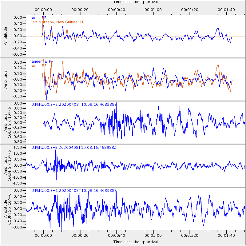
PMG Port Moresby, New Guinea - Earthquake Result Viewer
*The percent match for this event was below the threshold and hence no stack was calculated.
| Earthquake location: |
Fiji Islands Region |
| Earthquake latitude/longitude: |
-15.7/-177.6 |
| Earthquake time(UTC): |
2020/04/08 (099) 10:02:32 GMT |
| Earthquake Depth: |
421 km |
| Earthquake Magnitude: |
5.5 Mww |
| Earthquake Catalog/Contributor: |
NEIC PDE/us |
|
| Network: |
IU Global Seismograph Network (GSN - IRIS/USGS) |
| Station: |
PMG Port Moresby, New Guinea |
| Lat/Lon: |
9.40 S/147.16 E |
| Elevation: |
90 m |
|
| Distance: |
34.9 deg |
| Az: |
276.008 deg |
| Baz: |
103.853 deg |
| Ray Param: |
$rayparam |
*The percent match for this event was below the threshold and hence was not used in the summary stack. |
|
| Radial Match: |
55.673077 % |
| Radial Bump: |
400 |
| Transverse Match: |
48.14048 % |
| Transverse Bump: |
400 |
| SOD ConfigId: |
21166931 |
| Insert Time: |
2020-05-07 11:24:16.886 +0000 |
| GWidth: |
2.5 |
| Max Bumps: |
400 |
| Tol: |
0.001 |
|
Signal To Noise
| Channel | StoN | STA | LTA |
| IU:PMG:00:BHZ:20200408T10:08:16.468988Z | 2.1772227 | 3.1948002E-7 | 1.467374E-7 |
| IU:PMG:00:BH1:20200408T10:08:16.468988Z | 1.5986626 | 1.7507402E-7 | 1.09512804E-7 |
| IU:PMG:00:BH2:20200408T10:08:16.468988Z | 1.092996 | 1.81933E-7 | 1.664535E-7 |
| Arrivals |
| Ps | |
| PpPs | |
| PsPs/PpSs | |


