You are here: Home > Network List > IW - Intermountain West Stations List
> Station MOOW Moose Ponds, Wyoming, USA > Earthquake Result Viewer
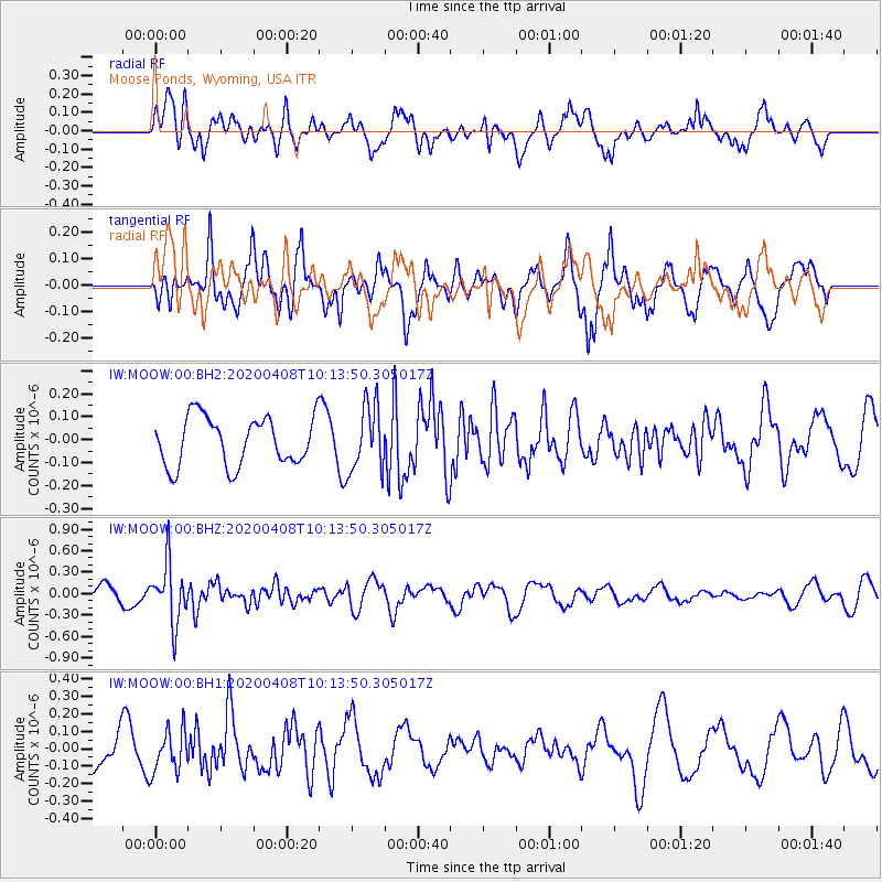
MOOW Moose Ponds, Wyoming, USA - Earthquake Result Viewer
*The percent match for this event was below the threshold and hence no stack was calculated.
| Earthquake location: |
Fiji Islands Region |
| Earthquake latitude/longitude: |
-15.7/-177.6 |
| Earthquake time(UTC): |
2020/04/08 (099) 10:02:32 GMT |
| Earthquake Depth: |
421 km |
| Earthquake Magnitude: |
5.5 Mww |
| Earthquake Catalog/Contributor: |
NEIC PDE/us |
|
| Network: |
IW Intermountain West |
| Station: |
MOOW Moose Ponds, Wyoming, USA |
| Lat/Lon: |
43.75 N/110.74 W |
| Elevation: |
2128 m |
|
| Distance: |
84.9 deg |
| Az: |
41.999 deg |
| Baz: |
242.805 deg |
| Ray Param: |
$rayparam |
*The percent match for this event was below the threshold and hence was not used in the summary stack. |
|
| Radial Match: |
58.442135 % |
| Radial Bump: |
400 |
| Transverse Match: |
67.48319 % |
| Transverse Bump: |
400 |
| SOD ConfigId: |
21166931 |
| Insert Time: |
2020-05-07 11:24:33.422 +0000 |
| GWidth: |
2.5 |
| Max Bumps: |
400 |
| Tol: |
0.001 |
|
Signal To Noise
| Channel | StoN | STA | LTA |
| IW:MOOW:00:BHZ:20200408T10:13:50.305017Z | 4.2976956 | 4.162843E-7 | 9.6862216E-8 |
| IW:MOOW:00:BH1:20200408T10:13:50.305017Z | 0.77257526 | 1.2070038E-7 | 1.5623122E-7 |
| IW:MOOW:00:BH2:20200408T10:13:50.305017Z | 1.3754189 | 1.4479961E-7 | 1.0527674E-7 |
| Arrivals |
| Ps | |
| PpPs | |
| PsPs/PpSs | |


