You are here: Home > Network List > TA - USArray Transportable Network (new EarthScope stations) Stations List
> Station C16K Lisburne Hills, AK, USA > Earthquake Result Viewer
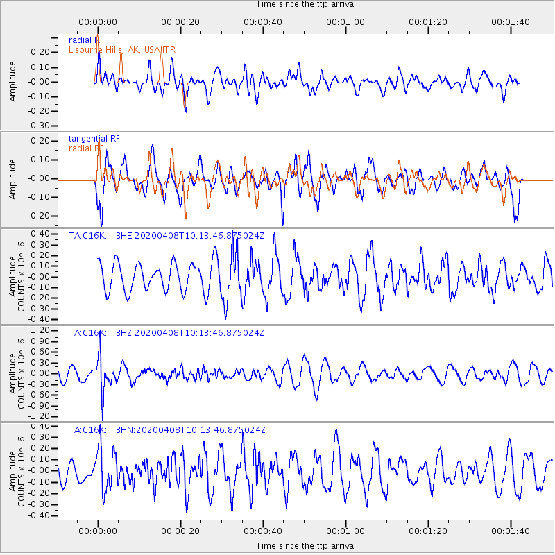
C16K Lisburne Hills, AK, USA - Earthquake Result Viewer
*The percent match for this event was below the threshold and hence no stack was calculated.
| Earthquake location: |
Fiji Islands Region |
| Earthquake latitude/longitude: |
-15.7/-177.6 |
| Earthquake time(UTC): |
2020/04/08 (099) 10:02:32 GMT |
| Earthquake Depth: |
421 km |
| Earthquake Magnitude: |
5.5 Mww |
| Earthquake Catalog/Contributor: |
NEIC PDE/us |
|
| Network: |
TA USArray Transportable Network (new EarthScope stations) |
| Station: |
C16K Lisburne Hills, AK, USA |
| Lat/Lon: |
68.27 N/165.34 W |
| Elevation: |
102 m |
|
| Distance: |
84.2 deg |
| Az: |
4.563 deg |
| Baz: |
191.878 deg |
| Ray Param: |
$rayparam |
*The percent match for this event was below the threshold and hence was not used in the summary stack. |
|
| Radial Match: |
36.7809 % |
| Radial Bump: |
400 |
| Transverse Match: |
74.17618 % |
| Transverse Bump: |
400 |
| SOD ConfigId: |
21166931 |
| Insert Time: |
2020-05-07 11:29:54.636 +0000 |
| GWidth: |
2.5 |
| Max Bumps: |
400 |
| Tol: |
0.001 |
|
Signal To Noise
| Channel | StoN | STA | LTA |
| TA:C16K: :BHZ:20200408T10:13:46.875024Z | 2.1676106 | 4.71811E-7 | 2.1766411E-7 |
| TA:C16K: :BHN:20200408T10:13:46.875024Z | 1.2854016 | 1.8981419E-7 | 1.4766917E-7 |
| TA:C16K: :BHE:20200408T10:13:46.875024Z | 1.8600606 | 2.2397863E-7 | 1.204147E-7 |
| Arrivals |
| Ps | |
| PpPs | |
| PsPs/PpSs | |


