You are here: Home > Network List > KN - Kyrgyz Seismic Telemetry Network Stations List
> Station CHM KN.CHM > Earthquake Result Viewer
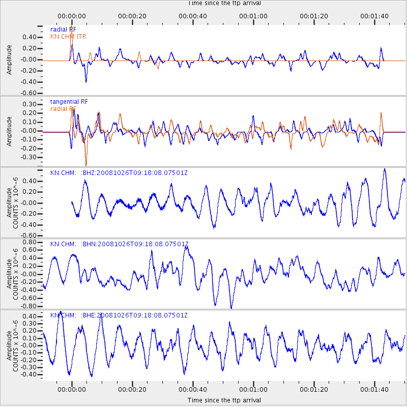
CHM KN.CHM - Earthquake Result Viewer
*The percent match for this event was below the threshold and hence no stack was calculated.
| Earthquake location: |
Minahassa Peninsula, Sulawesi |
| Earthquake latitude/longitude: |
-0.1/123.0 |
| Earthquake time(UTC): |
2008/10/26 (300) 09:08:34 GMT |
| Earthquake Depth: |
81 km |
| Earthquake Magnitude: |
5.5 MB, 5.6 MW, 5.6 MW |
| Earthquake Catalog/Contributor: |
WHDF/NEIC |
|
| Network: |
KN Kyrgyz Seismic Telemetry Network |
| Station: |
CHM KN.CHM |
| Lat/Lon: |
43.00 N/74.75 E |
| Elevation: |
655 m |
|
| Distance: |
60.9 deg |
| Az: |
321.192 deg |
| Baz: |
121.325 deg |
| Ray Param: |
$rayparam |
*The percent match for this event was below the threshold and hence was not used in the summary stack. |
|
| Radial Match: |
67.03995 % |
| Radial Bump: |
400 |
| Transverse Match: |
56.43458 % |
| Transverse Bump: |
400 |
| SOD ConfigId: |
2560 |
| Insert Time: |
2010-03-08 19:35:52.264 +0000 |
| GWidth: |
2.5 |
| Max Bumps: |
400 |
| Tol: |
0.001 |
|
Signal To Noise
| Channel | StoN | STA | LTA |
| KN:CHM: :BHN:20081026T09:18:08.07501Z | 1.3910973 | 3.5487696E-7 | 2.551058E-7 |
| KN:CHM: :BHE:20081026T09:18:08.07501Z | 1.2365358 | 2.3615435E-7 | 1.909806E-7 |
| KN:CHM: :BHZ:20081026T09:18:08.07501Z | 1.0907196 | 1.5907827E-7 | 1.4584708E-7 |
| Arrivals |
| Ps | |
| PpPs | |
| PsPs/PpSs | |


