You are here: Home > Network List > TA - USArray Transportable Network (new EarthScope stations) Stations List
> Station M11K Mekoryuk, AK, USA > Earthquake Result Viewer
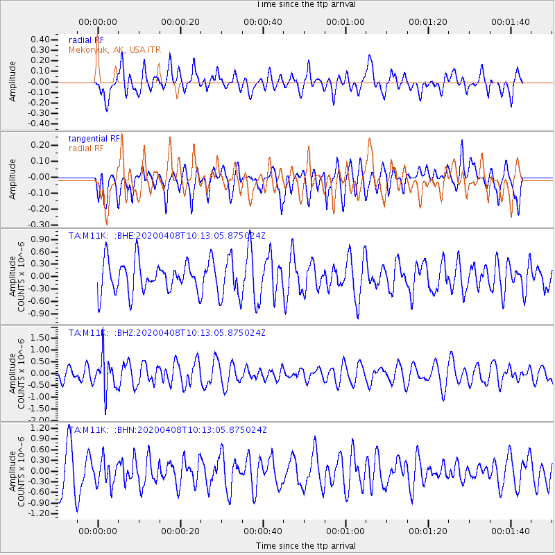
M11K Mekoryuk, AK, USA - Earthquake Result Viewer
*The percent match for this event was below the threshold and hence no stack was calculated.
| Earthquake location: |
Fiji Islands Region |
| Earthquake latitude/longitude: |
-15.7/-177.6 |
| Earthquake time(UTC): |
2020/04/08 (099) 10:02:32 GMT |
| Earthquake Depth: |
421 km |
| Earthquake Magnitude: |
5.5 Mww |
| Earthquake Catalog/Contributor: |
NEIC PDE/us |
|
| Network: |
TA USArray Transportable Network (new EarthScope stations) |
| Station: |
M11K Mekoryuk, AK, USA |
| Lat/Lon: |
60.38 N/166.20 W |
| Elevation: |
3.0 m |
|
| Distance: |
76.3 deg |
| Az: |
5.806 deg |
| Baz: |
191.315 deg |
| Ray Param: |
$rayparam |
*The percent match for this event was below the threshold and hence was not used in the summary stack. |
|
| Radial Match: |
40.180096 % |
| Radial Bump: |
400 |
| Transverse Match: |
43.850914 % |
| Transverse Bump: |
387 |
| SOD ConfigId: |
21166931 |
| Insert Time: |
2020-05-07 11:31:19.264 +0000 |
| GWidth: |
2.5 |
| Max Bumps: |
400 |
| Tol: |
0.001 |
|
Signal To Noise
| Channel | StoN | STA | LTA |
| TA:M11K: :BHZ:20200408T10:13:05.875024Z | 2.5689025 | 7.0437795E-7 | 2.7419412E-7 |
| TA:M11K: :BHN:20200408T10:13:05.875024Z | 0.6089131 | 3.4894717E-7 | 5.730656E-7 |
| TA:M11K: :BHE:20200408T10:13:05.875024Z | 1.3151252 | 4.8219636E-7 | 3.6665432E-7 |
| Arrivals |
| Ps | |
| PpPs | |
| PsPs/PpSs | |


