You are here: Home > Network List > TA - USArray Transportable Network (new EarthScope stations) Stations List
> Station O17K Koliganek, Bristol Bay, AK, USA > Earthquake Result Viewer
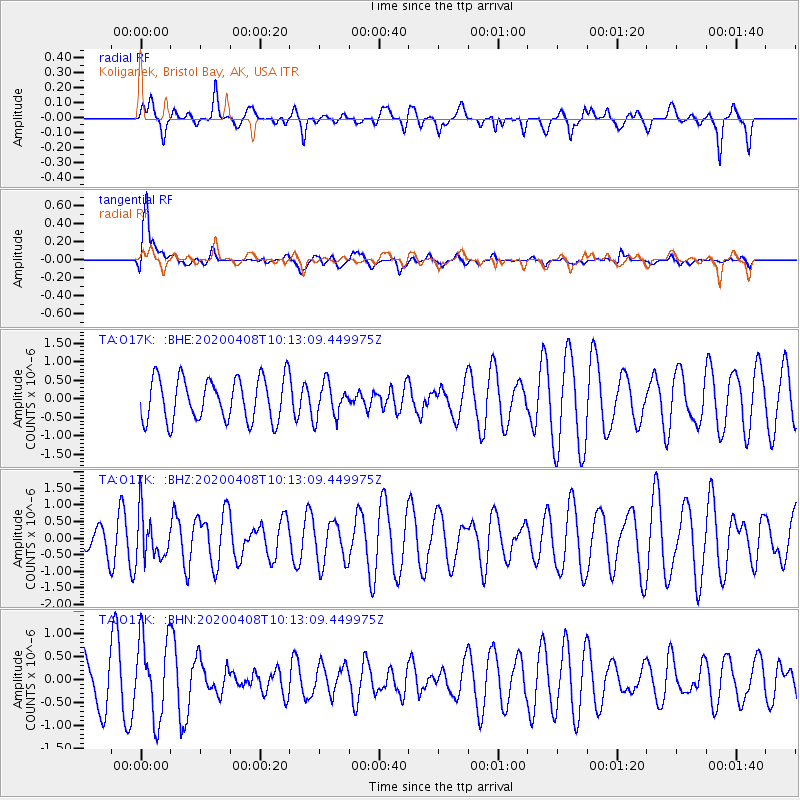
O17K Koliganek, Bristol Bay, AK, USA - Earthquake Result Viewer
*The percent match for this event was below the threshold and hence no stack was calculated.
| Earthquake location: |
Fiji Islands Region |
| Earthquake latitude/longitude: |
-15.7/-177.6 |
| Earthquake time(UTC): |
2020/04/08 (099) 10:02:32 GMT |
| Earthquake Depth: |
421 km |
| Earthquake Magnitude: |
5.5 Mww |
| Earthquake Catalog/Contributor: |
NEIC PDE/us |
|
| Network: |
TA USArray Transportable Network (new EarthScope stations) |
| Station: |
O17K Koliganek, Bristol Bay, AK, USA |
| Lat/Lon: |
59.77 N/157.09 W |
| Elevation: |
156 m |
|
| Distance: |
77.0 deg |
| Az: |
10.488 deg |
| Baz: |
200.279 deg |
| Ray Param: |
$rayparam |
*The percent match for this event was below the threshold and hence was not used in the summary stack. |
|
| Radial Match: |
38.49589 % |
| Radial Bump: |
400 |
| Transverse Match: |
82.7279 % |
| Transverse Bump: |
400 |
| SOD ConfigId: |
21166931 |
| Insert Time: |
2020-05-07 11:31:38.633 +0000 |
| GWidth: |
2.5 |
| Max Bumps: |
400 |
| Tol: |
0.001 |
|
Signal To Noise
| Channel | StoN | STA | LTA |
| TA:O17K: :BHZ:20200408T10:13:09.449975Z | 1.6604202 | 6.9494797E-7 | 4.185374E-7 |
| TA:O17K: :BHN:20200408T10:13:09.449975Z | 1.6629974 | 8.890879E-7 | 5.3462975E-7 |
| TA:O17K: :BHE:20200408T10:13:09.449975Z | 0.81203276 | 4.6836752E-7 | 5.7678403E-7 |
| Arrivals |
| Ps | |
| PpPs | |
| PsPs/PpSs | |


