You are here: Home > Network List > KN - Kyrgyz Seismic Telemetry Network Stations List
> Station CHM KN.CHM > Earthquake Result Viewer
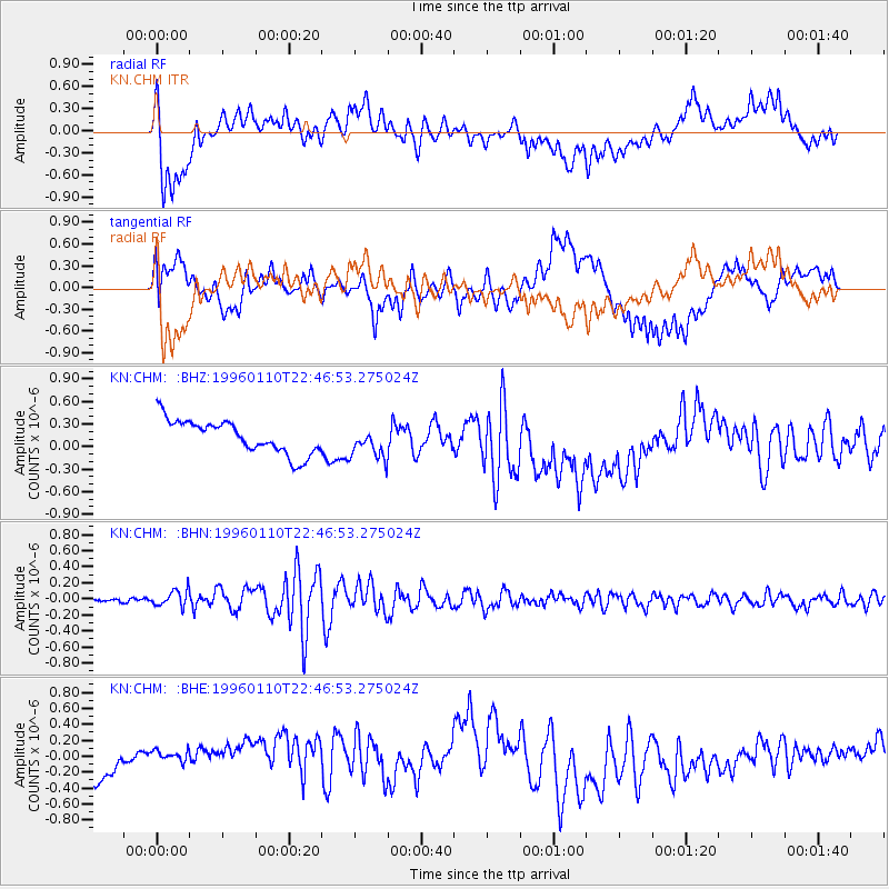
CHM KN.CHM - Earthquake Result Viewer
*The percent match for this event was below the threshold and hence no stack was calculated.
| Earthquake location: |
Aru Islands Region, Indonesia |
| Earthquake latitude/longitude: |
-6.1/133.6 |
| Earthquake time(UTC): |
1996/01/10 (010) 22:36:03 GMT |
| Earthquake Depth: |
37 km |
| Earthquake Magnitude: |
5.8 MB, 5.6 MS, 6.0 UNKNOWN, 5.9 MW |
| Earthquake Catalog/Contributor: |
WHDF/NEIC |
|
| Network: |
KN Kyrgyz Seismic Telemetry Network |
| Station: |
CHM KN.CHM |
| Lat/Lon: |
43.00 N/74.75 E |
| Elevation: |
655 m |
|
| Distance: |
72.2 deg |
| Az: |
318.754 deg |
| Baz: |
116.672 deg |
| Ray Param: |
$rayparam |
*The percent match for this event was below the threshold and hence was not used in the summary stack. |
|
| Radial Match: |
51.8966 % |
| Radial Bump: |
400 |
| Transverse Match: |
63.479294 % |
| Transverse Bump: |
400 |
| SOD ConfigId: |
4480 |
| Insert Time: |
2010-03-08 19:36:04.290 +0000 |
| GWidth: |
2.5 |
| Max Bumps: |
400 |
| Tol: |
0.001 |
|
Signal To Noise
| Channel | StoN | STA | LTA |
| KN:CHM: :BHN:19960110T22:46:53.275024Z | 2.204942 | 1.07198865E-7 | 4.8617544E-8 |
| KN:CHM: :BHE:19960110T22:46:53.275024Z | 0.44009453 | 1.4704482E-7 | 3.3412098E-7 |
| KN:CHM: :BHZ:19960110T22:46:53.275024Z | 0.9548802 | 2.1123374E-7 | 2.2121492E-7 |
| Arrivals |
| Ps | |
| PpPs | |
| PsPs/PpSs | |


