You are here: Home > Network List > KN - Kyrgyz Seismic Telemetry Network Stations List
> Station CHM KN.CHM > Earthquake Result Viewer
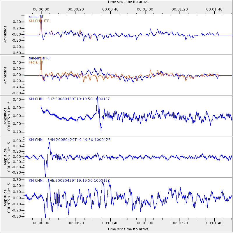
CHM KN.CHM - Earthquake Result Viewer
*The percent match for this event was below the threshold and hence no stack was calculated.
| Earthquake location: |
Banda Sea |
| Earthquake latitude/longitude: |
-6.1/127.5 |
| Earthquake time(UTC): |
2008/04/29 (120) 19:10:02 GMT |
| Earthquake Depth: |
405 km |
| Earthquake Magnitude: |
5.6 MB, 5.9 MW, 5.9 MW |
| Earthquake Catalog/Contributor: |
WHDF/NEIC |
|
| Network: |
KN Kyrgyz Seismic Telemetry Network |
| Station: |
CHM KN.CHM |
| Lat/Lon: |
43.00 N/74.75 E |
| Elevation: |
655 m |
|
| Distance: |
68.3 deg |
| Az: |
321.065 deg |
| Baz: |
121.593 deg |
| Ray Param: |
$rayparam |
*The percent match for this event was below the threshold and hence was not used in the summary stack. |
|
| Radial Match: |
71.278725 % |
| Radial Bump: |
400 |
| Transverse Match: |
52.499676 % |
| Transverse Bump: |
400 |
| SOD ConfigId: |
2504 |
| Insert Time: |
2010-03-08 19:36:29.739 +0000 |
| GWidth: |
2.5 |
| Max Bumps: |
400 |
| Tol: |
0.001 |
|
Signal To Noise
| Channel | StoN | STA | LTA |
| KN:CHM: :BHN:20080429T19:19:50.100012Z | 12.572578 | 4.6940903E-7 | 3.733594E-8 |
| KN:CHM: :BHE:20080429T19:19:50.100012Z | 3.3718905 | 1.5251335E-7 | 4.5230813E-8 |
| KN:CHM: :BHZ:20080429T19:19:50.100012Z | 2.4167647 | 1.987891E-7 | 8.225422E-8 |
| Arrivals |
| Ps | |
| PpPs | |
| PsPs/PpSs | |


