You are here: Home > Network List > TS - TERRAscope (Southern California Seismic Network) Stations List
> Station SBC Santa Barbara, California, USA > Earthquake Result Viewer
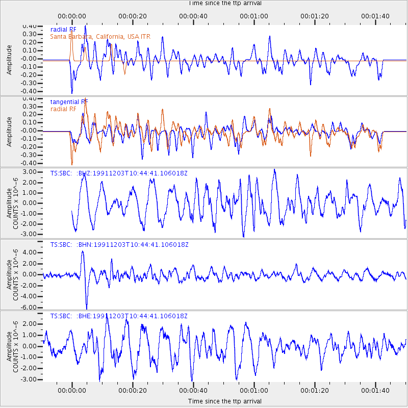
SBC Santa Barbara, California, USA - Earthquake Result Viewer
*The percent match for this event was below the threshold and hence no stack was calculated.
| Earthquake location: |
South Of Fiji Islands |
| Earthquake latitude/longitude: |
-26.3/178.6 |
| Earthquake time(UTC): |
1991/12/03 (337) 10:33:42 GMT |
| Earthquake Depth: |
581 km |
| Earthquake Magnitude: |
5.8 MB |
| Earthquake Catalog/Contributor: |
WHDF/NEIC |
|
| Network: |
TS TERRAscope (Southern California Seismic Network) |
| Station: |
SBC Santa Barbara, California, USA |
| Lat/Lon: |
34.44 N/119.71 W |
| Elevation: |
90 m |
|
| Distance: |
84.1 deg |
| Az: |
47.031 deg |
| Baz: |
232.623 deg |
| Ray Param: |
$rayparam |
*The percent match for this event was below the threshold and hence was not used in the summary stack. |
|
| Radial Match: |
52.143414 % |
| Radial Bump: |
400 |
| Transverse Match: |
39.17139 % |
| Transverse Bump: |
335 |
| SOD ConfigId: |
4480 |
| Insert Time: |
2010-02-26 14:48:43.681 +0000 |
| GWidth: |
2.5 |
| Max Bumps: |
400 |
| Tol: |
0.001 |
|
Signal To Noise
| Channel | StoN | STA | LTA |
| TS:SBC: :BHN:19911203T10:44:41.106018Z | 4.6148663 | 2.1500227E-6 | 4.658906E-7 |
| TS:SBC: :BHE:19911203T10:44:41.106018Z | 1.7076374 | 9.1064163E-7 | 5.3327574E-7 |
| TS:SBC: :BHZ:19911203T10:44:41.106018Z | 0.97682685 | 1.3480347E-6 | 1.380014E-6 |
| Arrivals |
| Ps | |
| PpPs | |
| PsPs/PpSs | |


