You are here: Home > Network List > KN - Kyrgyz Seismic Telemetry Network Stations List
> Station CHM KN.CHM > Earthquake Result Viewer
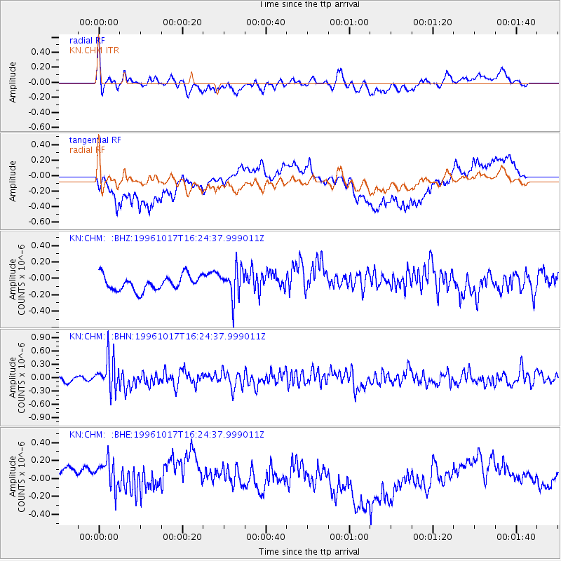
CHM KN.CHM - Earthquake Result Viewer
*The percent match for this event was below the threshold and hence no stack was calculated.
| Earthquake location: |
Mindanao, Philippines |
| Earthquake latitude/longitude: |
5.7/125.9 |
| Earthquake time(UTC): |
1996/10/17 (291) 16:15:25 GMT |
| Earthquake Depth: |
117 km |
| Earthquake Magnitude: |
5.7 MB, 5.9 UNKNOWN, 5.9 MW |
| Earthquake Catalog/Contributor: |
WHDF/NEIC |
|
| Network: |
KN Kyrgyz Seismic Telemetry Network |
| Station: |
CHM KN.CHM |
| Lat/Lon: |
43.00 N/74.75 E |
| Elevation: |
655 m |
|
| Distance: |
58.4 deg |
| Az: |
317.814 deg |
| Baz: |
114.374 deg |
| Ray Param: |
$rayparam |
*The percent match for this event was below the threshold and hence was not used in the summary stack. |
|
| Radial Match: |
60.51593 % |
| Radial Bump: |
400 |
| Transverse Match: |
54.925144 % |
| Transverse Bump: |
400 |
| SOD ConfigId: |
4480 |
| Insert Time: |
2010-03-08 19:37:00.368 +0000 |
| GWidth: |
2.5 |
| Max Bumps: |
400 |
| Tol: |
0.001 |
|
Signal To Noise
| Channel | StoN | STA | LTA |
| KN:CHM: :BHN:19961017T16:24:37.999011Z | 3.7611136 | 3.7106633E-7 | 9.865863E-8 |
| KN:CHM: :BHE:19961017T16:24:37.999011Z | 1.24861 | 3.5141372E-7 | 2.8144393E-7 |
| KN:CHM: :BHZ:19961017T16:24:37.999011Z | 2.1294706 | 1.8831169E-7 | 8.843122E-8 |
| Arrivals |
| Ps | |
| PpPs | |
| PsPs/PpSs | |


