You are here: Home > Network List > TA - USArray Transportable Network (new EarthScope stations) Stations List
> Station I30M Mount Dempster, Yukon, CAN > Earthquake Result Viewer
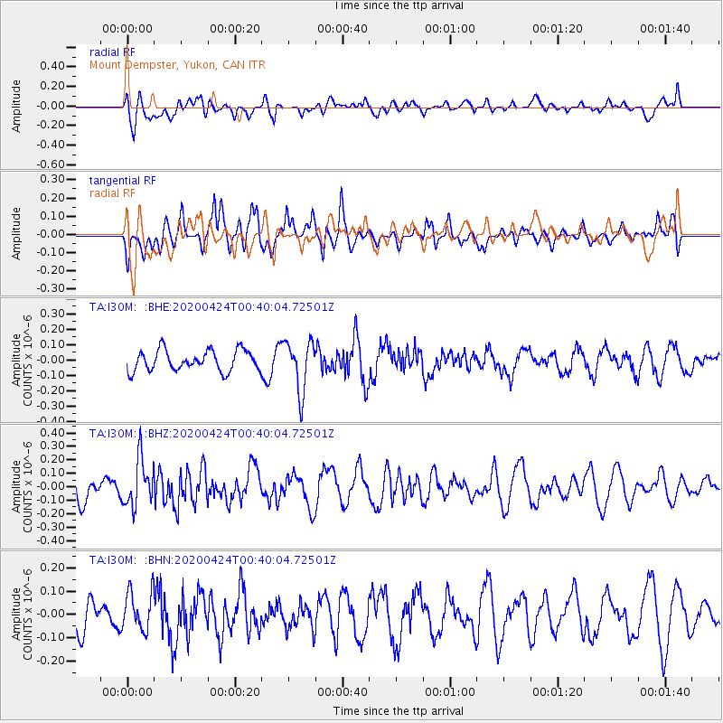
I30M Mount Dempster, Yukon, CAN - Earthquake Result Viewer
*The percent match for this event was below the threshold and hence no stack was calculated.
| Earthquake location: |
Off Coast Of Chiapas, Mexico |
| Earthquake latitude/longitude: |
13.9/-93.1 |
| Earthquake time(UTC): |
2020/04/24 (115) 00:30:39 GMT |
| Earthquake Depth: |
35 km |
| Earthquake Magnitude: |
5.5 Mww |
| Earthquake Catalog/Contributor: |
NEIC PDE/us |
|
| Network: |
TA USArray Transportable Network (new EarthScope stations) |
| Station: |
I30M Mount Dempster, Yukon, CAN |
| Lat/Lon: |
65.22 N/136.38 W |
| Elevation: |
1399 m |
|
| Distance: |
59.0 deg |
| Az: |
340.306 deg |
| Baz: |
129.06 deg |
| Ray Param: |
$rayparam |
*The percent match for this event was below the threshold and hence was not used in the summary stack. |
|
| Radial Match: |
48.23187 % |
| Radial Bump: |
400 |
| Transverse Match: |
70.10854 % |
| Transverse Bump: |
400 |
| SOD ConfigId: |
21166931 |
| Insert Time: |
2020-05-08 00:44:28.144 +0000 |
| GWidth: |
2.5 |
| Max Bumps: |
400 |
| Tol: |
0.001 |
|
Signal To Noise
| Channel | StoN | STA | LTA |
| TA:I30M: :BHZ:20200424T00:40:04.72501Z | 1.8307303 | 1.7966327E-7 | 9.813749E-8 |
| TA:I30M: :BHN:20200424T00:40:04.72501Z | 1.3008733 | 8.604149E-8 | 6.614133E-8 |
| TA:I30M: :BHE:20200424T00:40:04.72501Z | 2.5106413 | 1.6702357E-7 | 6.6526255E-8 |
| Arrivals |
| Ps | |
| PpPs | |
| PsPs/PpSs | |


